You are here: Home > Network List > TA - USArray Transportable Network (new EarthScope stations) Stations List
> Station M22K Willow, AK, USA > Earthquake Result Viewer
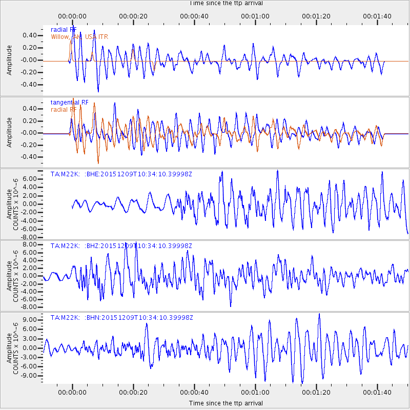
M22K Willow, AK, USA - Earthquake Result Viewer
| Earthquake location: |
Banda Sea |
| Earthquake latitude/longitude: |
-4.1/129.5 |
| Earthquake time(UTC): |
2015/12/09 (343) 10:21:50 GMT |
| Earthquake Depth: |
34 km |
| Earthquake Magnitude: |
6.9 MWP |
| Earthquake Catalog/Contributor: |
NEIC PDE/NEIC COMCAT |
|
| Network: |
TA USArray Transportable Network (new EarthScope stations) |
| Station: |
M22K Willow, AK, USA |
| Lat/Lon: |
61.75 N/150.12 W |
| Elevation: |
57 m |
|
| Distance: |
89.1 deg |
| Az: |
27.979 deg |
| Baz: |
259.616 deg |
| Ray Param: |
0.042081732 |
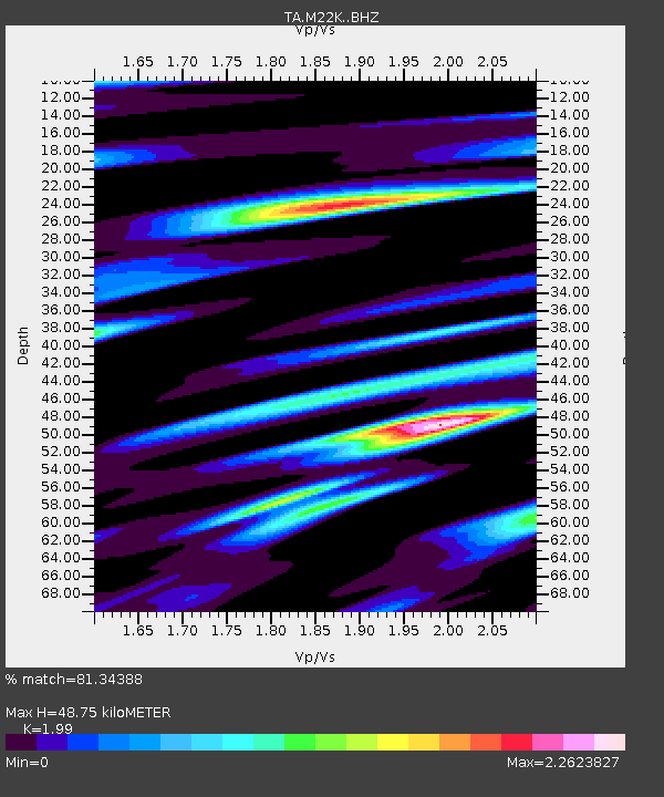
| Estimated Moho Depth: |
48.75 km |
| Estimated Crust Vp/Vs: |
1.99 |
| Assumed Crust Vp: |
6.302 km/s |
| Estimated Crust Vs: |
3.167 km/s |
| Estimated Crust Poisson's Ratio: |
0.33 |
|
| Radial Match: |
81.34388 % |
| Radial Bump: |
400 |
| Transverse Match: |
77.54847 % |
| Transverse Bump: |
400 |
| SOD ConfigId: |
7422571 |
| Insert Time: |
2019-04-21 14:09:13.682 +0000 |
| GWidth: |
2.5 |
| Max Bumps: |
400 |
| Tol: |
0.001 |
|
Signal To Noise
| Channel | StoN | STA | LTA |
| TA:M22K: :BHZ:20151209T10:34:10.39998Z | 3.9256966 | 1.9142344E-6 | 4.876165E-7 |
| TA:M22K: :BHN:20151209T10:34:10.39998Z | 0.72921515 | 9.540189E-7 | 1.3082818E-6 |
| TA:M22K: :BHE:20151209T10:34:10.39998Z | 1.4179634 | 1.3744772E-6 | 9.69332E-7 |
| Arrivals |
| Ps | 7.8 SECOND |
| PpPs | 23 SECOND |
| PsPs/PpSs | 31 SECOND |


