You are here: Home > Network List > IC - New China Digital Seismograph Network Stations List
> Station LSA Tibet, China > Earthquake Result Viewer
LSA Tibet, China - Earthquake Result Viewer
| Earthquake location: |
Mid-Indian Ridge |
| Earthquake latitude/longitude: |
-36.9/78.5 |
| Earthquake time(UTC): |
1996/08/27 (240) 10:50:49 GMT |
| Earthquake Depth: |
10 km |
| Earthquake Magnitude: |
5.8 MS, 5.3 MB, 5.9 UNKNOWN, 5.9 MW |
| Earthquake Catalog/Contributor: |
WHDF/NEIC |
|
| Network: |
IC New China Digital Seismograph Network |
| Station: |
LSA Tibet, China |
| Lat/Lon: |
29.70 N/91.15 E |
| Elevation: |
3789 m |
|
| Distance: |
67.3 deg |
| Az: |
11.933 deg |
| Baz: |
190.985 deg |
| Ray Param: |
0.057052046 |
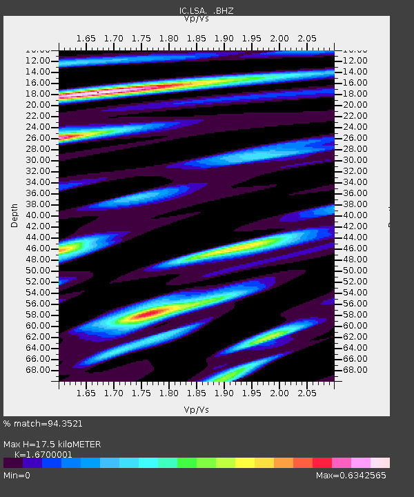
| Estimated Moho Depth: |
17.5 km |
| Estimated Crust Vp/Vs: |
1.67 |
| Assumed Crust Vp: |
6.514 km/s |
| Estimated Crust Vs: |
3.901 km/s |
| Estimated Crust Poisson's Ratio: |
0.22 |
|
| Radial Match: |
94.3521 % |
| Radial Bump: |
400 |
| Transverse Match: |
84.41149 % |
| Transverse Bump: |
400 |
| SOD ConfigId: |
4480 |
| Insert Time: |
2010-03-04 22:41:47.564 +0000 |
| GWidth: |
2.5 |
| Max Bumps: |
400 |
| Tol: |
0.001 |
|
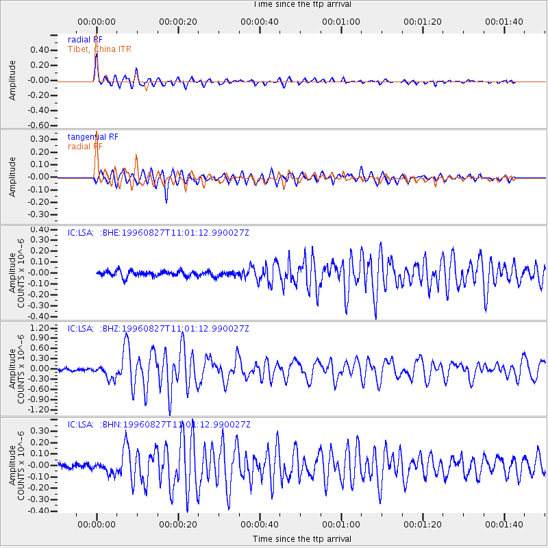
Signal To Noise
| Channel | StoN | STA | LTA |
| IC:LSA: :BHZ:19960827T11:01:12.990027Z | 4.4772153 | 2.0377914E-7 | 4.5514707E-8 |
| IC:LSA: :BHN:19960827T11:01:12.990027Z | 1.9972748 | 4.793551E-8 | 2.4000459E-8 |
| IC:LSA: :BHE:19960827T11:01:12.990027Z | 0.8579701 | 2.1942517E-8 | 2.557492E-8 |
| Arrivals |
| Ps | 1.9 SECOND |
| PpPs | 6.9 SECOND |
| PsPs/PpSs | 8.7 SECOND |


