You are here: Home > Network List > IC - New China Digital Seismograph Network Stations List
> Station LSA Tibet, China > Earthquake Result Viewer
LSA Tibet, China - Earthquake Result Viewer
| Earthquake location: |
Southeast Indian Ridge |
| Earthquake latitude/longitude: |
-48.0/99.5 |
| Earthquake time(UTC): |
1995/08/29 (241) 07:25:48 GMT |
| Earthquake Depth: |
10 km |
| Earthquake Magnitude: |
5.3 MB, 6.2 MS, 5.7 UNKNOWN, 6.4 MW |
| Earthquake Catalog/Contributor: |
WHDF/NEIC |
|
| Network: |
IC New China Digital Seismograph Network |
| Station: |
LSA Tibet, China |
| Lat/Lon: |
29.70 N/91.15 E |
| Elevation: |
3789 m |
|
| Distance: |
77.7 deg |
| Az: |
352.611 deg |
| Baz: |
174.302 deg |
| Ray Param: |
0.050149847 |
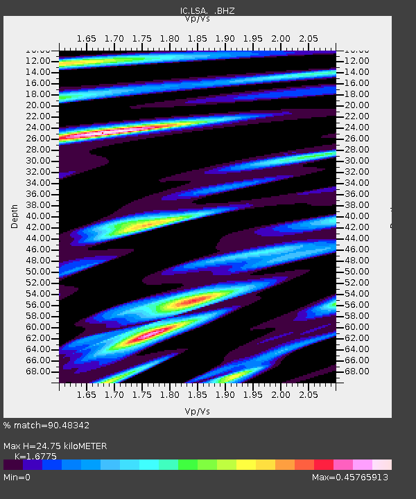
| Estimated Moho Depth: |
24.75 km |
| Estimated Crust Vp/Vs: |
1.68 |
| Assumed Crust Vp: |
6.514 km/s |
| Estimated Crust Vs: |
3.883 km/s |
| Estimated Crust Poisson's Ratio: |
0.22 |
|
| Radial Match: |
90.48342 % |
| Radial Bump: |
400 |
| Transverse Match: |
84.452255 % |
| Transverse Bump: |
400 |
| SOD ConfigId: |
4480 |
| Insert Time: |
2010-03-04 22:41:51.874 +0000 |
| GWidth: |
2.5 |
| Max Bumps: |
400 |
| Tol: |
0.001 |
|
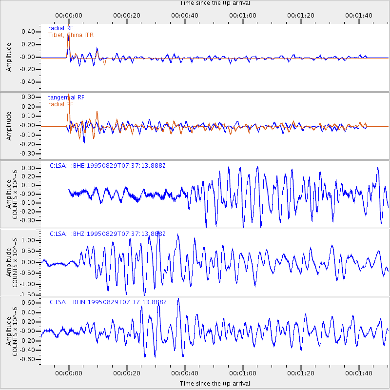
Signal To Noise
| Channel | StoN | STA | LTA |
| IC:LSA: :BHZ:19950829T07:37:13.888Z | 1.9093397 | 1.8195351E-7 | 9.529656E-8 |
| IC:LSA: :BHN:19950829T07:37:13.888Z | 0.97465 | 4.070391E-8 | 4.176259E-8 |
| IC:LSA: :BHE:19950829T07:37:13.888Z | 0.614582 | 2.7016794E-8 | 4.3959623E-8 |
| Arrivals |
| Ps | 2.7 SECOND |
| PpPs | 9.8 SECOND |
| PsPs/PpSs | 13 SECOND |


