You are here: Home > Network List > XL12 - Hangay Dome, Mongolia Stations List
> Station AT14 AT14 > Earthquake Result Viewer
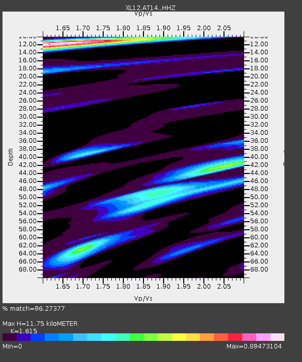
AT14 AT14 - Earthquake Result Viewer
| Earthquake location: |
Banda Sea |
| Earthquake latitude/longitude: |
-4.1/129.5 |
| Earthquake time(UTC): |
2015/12/09 (343) 10:21:50 GMT |
| Earthquake Depth: |
34 km |
| Earthquake Magnitude: |
6.9 MWP |
| Earthquake Catalog/Contributor: |
NEIC PDE/NEIC COMCAT |
|
| Network: |
XL Hangay Dome, Mongolia |
| Station: |
AT14 AT14 |
| Lat/Lon: |
45.36 N/96.64 E |
| Elevation: |
2289 m |
|
| Distance: |
57.3 deg |
| Az: |
332.972 deg |
| Baz: |
139.995 deg |
| Ray Param: |
0.0635221 |
| Estimated Moho Depth: |
11.75 km |
| Estimated Crust Vp/Vs: |
1.62 |
| Assumed Crust Vp: |
6.353 km/s |
| Estimated Crust Vs: |
3.934 km/s |
| Estimated Crust Poisson's Ratio: |
0.19 |
|
| Radial Match: |
96.27377 % |
| Radial Bump: |
400 |
| Transverse Match: |
80.14078 % |
| Transverse Bump: |
400 |
| SOD ConfigId: |
7422571 |
| Insert Time: |
2019-04-21 14:09:45.937 +0000 |
| GWidth: |
2.5 |
| Max Bumps: |
400 |
| Tol: |
0.001 |
|

Signal To Noise
| Channel | StoN | STA | LTA |
| XL:AT14: :HHZ:20151209T10:31:03.709001Z | 16.843874 | 1.3754723E-6 | 8.16601E-8 |
| XL:AT14: :HHN:20151209T10:31:03.709001Z | 3.5340962 | 5.5278156E-7 | 1.5641383E-7 |
| XL:AT14: :HHE:20151209T10:31:03.709001Z | 3.1455138 | 5.095856E-7 | 1.6200393E-7 |
| Arrivals |
| Ps | 1.2 SECOND |
| PpPs | 4.6 SECOND |
| PsPs/PpSs | 5.8 SECOND |


