You are here: Home > Network List > XL12 - Hangay Dome, Mongolia Stations List
> Station HV31 HV31 > Earthquake Result Viewer
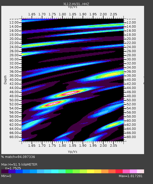
HV31 HV31 - Earthquake Result Viewer
| Earthquake location: |
Banda Sea |
| Earthquake latitude/longitude: |
-4.1/129.5 |
| Earthquake time(UTC): |
2015/12/09 (343) 10:21:50 GMT |
| Earthquake Depth: |
34 km |
| Earthquake Magnitude: |
6.9 MWP |
| Earthquake Catalog/Contributor: |
NEIC PDE/NEIC COMCAT |
|
| Network: |
XL Hangay Dome, Mongolia |
| Station: |
HV31 HV31 |
| Lat/Lon: |
51.34 N/100.24 E |
| Elevation: |
1693 m |
|
| Distance: |
60.6 deg |
| Az: |
339.419 deg |
| Baz: |
146.016 deg |
| Ray Param: |
0.061347127 |
| Estimated Moho Depth: |
51.5 km |
| Estimated Crust Vp/Vs: |
1.75 |
| Assumed Crust Vp: |
6.419 km/s |
| Estimated Crust Vs: |
3.663 km/s |
| Estimated Crust Poisson's Ratio: |
0.26 |
|
| Radial Match: |
94.097336 % |
| Radial Bump: |
400 |
| Transverse Match: |
85.28225 % |
| Transverse Bump: |
400 |
| SOD ConfigId: |
7422571 |
| Insert Time: |
2019-04-21 14:10:06.485 +0000 |
| GWidth: |
2.5 |
| Max Bumps: |
400 |
| Tol: |
0.001 |
|

Signal To Noise
| Channel | StoN | STA | LTA |
| XL:HV31: :HHZ:20151209T10:31:26.758989Z | 31.618761 | 2.5499253E-6 | 8.0645954E-8 |
| XL:HV31: :HHN:20151209T10:31:26.758989Z | 8.17968 | 1.0157768E-6 | 1.2418295E-7 |
| XL:HV31: :HHE:20151209T10:31:26.758989Z | 2.1020272 | 8.4549276E-7 | 4.0222733E-7 |
| Arrivals |
| Ps | 6.3 SECOND |
| PpPs | 21 SECOND |
| PsPs/PpSs | 27 SECOND |


