You are here: Home > Network List > IC - New China Digital Seismograph Network Stations List
> Station LSA Tibet, China > Earthquake Result Viewer
LSA Tibet, China - Earthquake Result Viewer
| Earthquake location: |
South Of Alaska |
| Earthquake latitude/longitude: |
53.8/-161.1 |
| Earthquake time(UTC): |
2002/05/25 (145) 05:36:31 GMT |
| Earthquake Depth: |
33 km |
| Earthquake Magnitude: |
5.5 MB, 6.1 MS, 6.5 MW, 6.4 MW |
| Earthquake Catalog/Contributor: |
WHDF/NEIC |
|
| Network: |
IC New China Digital Seismograph Network |
| Station: |
LSA Tibet, China |
| Lat/Lon: |
29.70 N/91.15 E |
| Elevation: |
3789 m |
|
| Distance: |
76.1 deg |
| Az: |
301.393 deg |
| Baz: |
35.575 deg |
| Ray Param: |
0.05115686 |
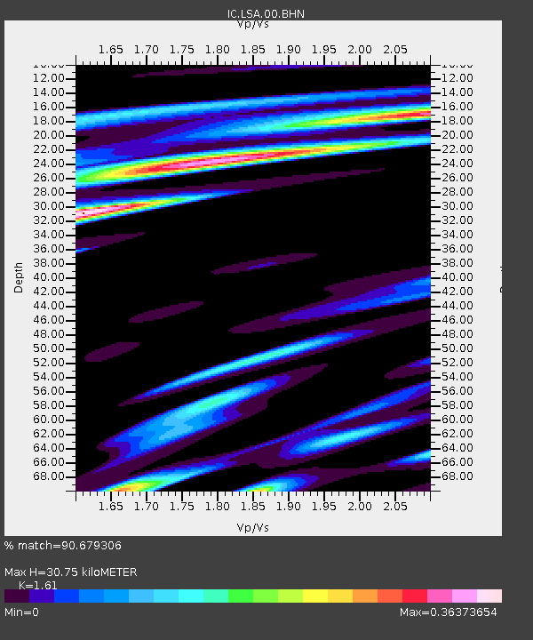
| Estimated Moho Depth: |
30.75 km |
| Estimated Crust Vp/Vs: |
1.61 |
| Assumed Crust Vp: |
6.514 km/s |
| Estimated Crust Vs: |
4.046 km/s |
| Estimated Crust Poisson's Ratio: |
0.19 |
|
| Radial Match: |
90.679306 % |
| Radial Bump: |
400 |
| Transverse Match: |
89.14535 % |
| Transverse Bump: |
400 |
| SOD ConfigId: |
20082 |
| Insert Time: |
2010-03-04 22:42:09.154 +0000 |
| GWidth: |
2.5 |
| Max Bumps: |
400 |
| Tol: |
0.001 |
|
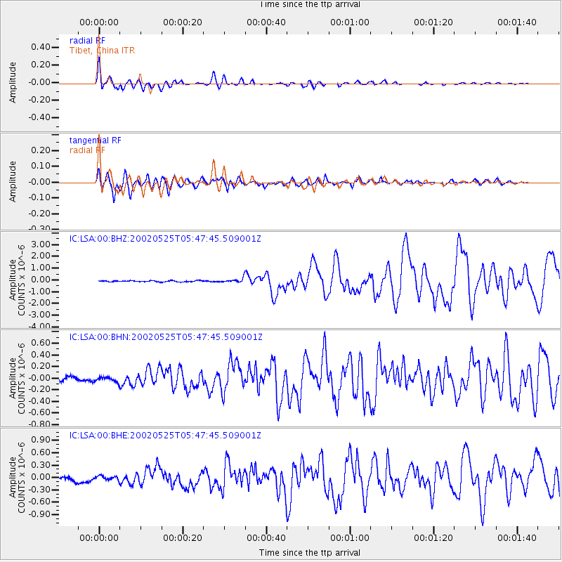
Signal To Noise
| Channel | StoN | STA | LTA |
| IC:LSA:00:BHN:20020525T05:47:45.509001Z | 1.5970446 | 4.799422E-8 | 3.0051897E-8 |
| IC:LSA:00:BHE:20020525T05:47:45.509001Z | 0.9366663 | 5.242271E-8 | 5.5967327E-8 |
| IC:LSA:00:BHZ:20020525T05:47:45.509001Z | 3.9695294 | 1.8701209E-7 | 4.7111904E-8 |
| Arrivals |
| Ps | 3.0 SECOND |
| PpPs | 12 SECOND |
| PsPs/PpSs | 15 SECOND |


