You are here: Home > Network List > IC - New China Digital Seismograph Network Stations List
> Station LSA Tibet, China > Earthquake Result Viewer
LSA Tibet, China - Earthquake Result Viewer
| Earthquake location: |
Mid-Indian Ridge |
| Earthquake latitude/longitude: |
-36.5/78.9 |
| Earthquake time(UTC): |
2002/05/14 (134) 16:56:10 GMT |
| Earthquake Depth: |
10 km |
| Earthquake Magnitude: |
5.6 MB, 6.1 MS, 6.3 MW, 6.1 MW |
| Earthquake Catalog/Contributor: |
WHDF/NEIC |
|
| Network: |
IC New China Digital Seismograph Network |
| Station: |
LSA Tibet, China |
| Lat/Lon: |
29.70 N/91.15 E |
| Elevation: |
3789 m |
|
| Distance: |
66.9 deg |
| Az: |
11.551 deg |
| Baz: |
190.684 deg |
| Ray Param: |
0.05733469 |
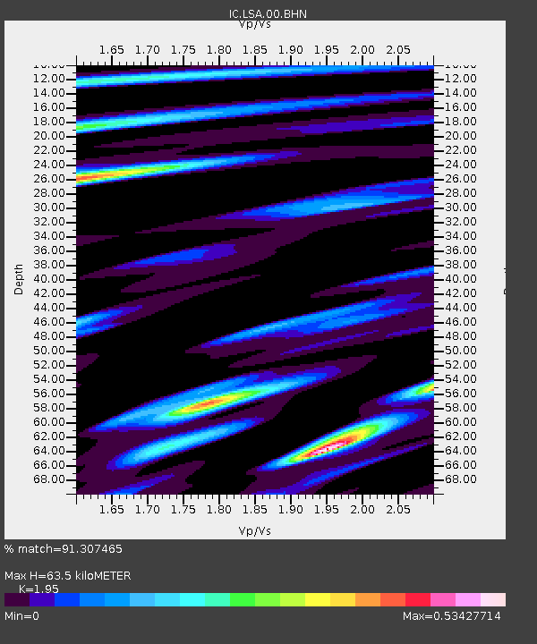
| Estimated Moho Depth: |
63.5 km |
| Estimated Crust Vp/Vs: |
1.95 |
| Assumed Crust Vp: |
6.514 km/s |
| Estimated Crust Vs: |
3.341 km/s |
| Estimated Crust Poisson's Ratio: |
0.32 |
|
| Radial Match: |
91.307465 % |
| Radial Bump: |
400 |
| Transverse Match: |
85.591 % |
| Transverse Bump: |
400 |
| SOD ConfigId: |
20082 |
| Insert Time: |
2010-03-04 22:42:13.574 +0000 |
| GWidth: |
2.5 |
| Max Bumps: |
400 |
| Tol: |
0.001 |
|
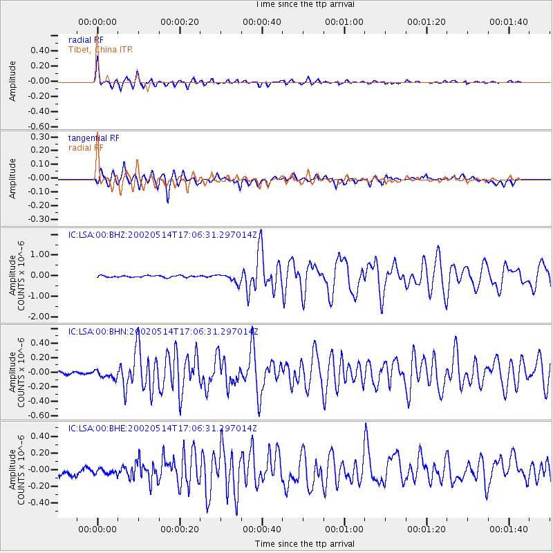
Signal To Noise
| Channel | StoN | STA | LTA |
| IC:LSA:00:BHN:20020514T17:06:31.297014Z | 2.0185993 | 5.5528982E-8 | 2.7508671E-8 |
| IC:LSA:00:BHE:20020514T17:06:31.297014Z | 0.8952648 | 3.9819845E-8 | 4.4478288E-8 |
| IC:LSA:00:BHZ:20020514T17:06:31.297014Z | 5.5128565 | 2.2797302E-7 | 4.1352973E-8 |
| Arrivals |
| Ps | 9.6 SECOND |
| PpPs | 28 SECOND |
| PsPs/PpSs | 37 SECOND |


