You are here: Home > Network List > IC - New China Digital Seismograph Network Stations List
> Station LSA Tibet, China > Earthquake Result Viewer
LSA Tibet, China - Earthquake Result Viewer
| Earthquake location: |
Banda Sea |
| Earthquake latitude/longitude: |
-6.5/129.9 |
| Earthquake time(UTC): |
2002/03/19 (078) 22:14:14 GMT |
| Earthquake Depth: |
148 km |
| Earthquake Magnitude: |
5.7 MB, 6.1 MW, 6.0 MW |
| Earthquake Catalog/Contributor: |
WHDF/NEIC |
|
| Network: |
IC New China Digital Seismograph Network |
| Station: |
LSA Tibet, China |
| Lat/Lon: |
29.70 N/91.15 E |
| Elevation: |
3789 m |
|
| Distance: |
51.8 deg |
| Az: |
316.103 deg |
| Baz: |
127.638 deg |
| Ray Param: |
0.06669657 |
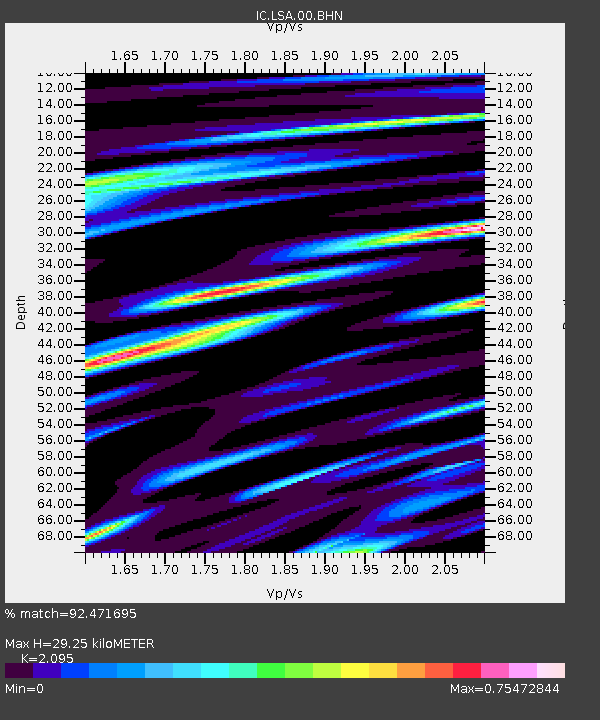
| Estimated Moho Depth: |
29.25 km |
| Estimated Crust Vp/Vs: |
2.10 |
| Assumed Crust Vp: |
6.514 km/s |
| Estimated Crust Vs: |
3.109 km/s |
| Estimated Crust Poisson's Ratio: |
0.35 |
|
| Radial Match: |
92.471695 % |
| Radial Bump: |
400 |
| Transverse Match: |
87.710075 % |
| Transverse Bump: |
400 |
| SOD ConfigId: |
20082 |
| Insert Time: |
2010-03-04 22:42:19.407 +0000 |
| GWidth: |
2.5 |
| Max Bumps: |
400 |
| Tol: |
0.001 |
|
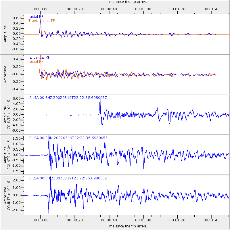
Signal To Noise
| Channel | StoN | STA | LTA |
| IC:LSA:00:BHN:20020319T22:22:36.698005Z | 21.757362 | 3.6090958E-7 | 1.658793E-8 |
| IC:LSA:00:BHE:20020319T22:22:36.698005Z | 16.744589 | 4.8753327E-7 | 2.9115869E-8 |
| IC:LSA:00:BHZ:20020319T22:22:36.698005Z | 28.27389 | 1.5465106E-6 | 5.4697484E-8 |
| Arrivals |
| Ps | 5.2 SECOND |
| PpPs | 13 SECOND |
| PsPs/PpSs | 18 SECOND |


