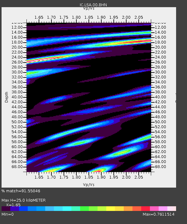
LSA Tibet, China - Earthquake Result Viewer
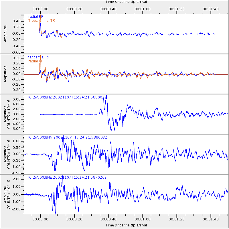
Earthquake location: Rat Islands, Aleutian Islands
Earthquake latitude/longitude: 51.2/179.3
Earthquake time(UTC): 2002/11/07 (311) 15:14:06 GMT
Earthquake Depth: 33 km
Earthquake Magnitude: 5.8 MB, 6.4 MS, 6.6 MW, 6.5 MW
Earthquake Catalog/Contributor: WHDF/NEIC
Network: IC New China Digital Seismograph Network
Station: LSA Tibet, China
Lat/Lon: 29.70 N/91.15 E
Elevation: 3789 m
Distance: 66.4 deg
Az: 288.367 deg
Baz: 43.34 deg
Ray Param: 0.057594933
Estimated Moho Depth: 25.0 km
Estimated Crust Vp/Vs: 1.65
Assumed Crust Vp: 6.514 km/s
Estimated Crust Vs: 3.948 km/s
Estimated Crust Poisson's Ratio: 0.21
Radial Match: 91.55846 %
Radial Bump: 400
Transverse Match: 82.47048 %
Transverse Bump: 400
SOD ConfigId: 4714
Insert Time: 2010-03-04 22:42:26.437 +0000
GWidth: 2.5
Max Bumps: 400
Tol: 0.001

Signal To Noise

ChannelStoNSTALTA
IC:LSA:00:BHN:20021107T15:24:21.588003Z1.74403773.9398536E-82.2590415E-8
IC:LSA:00:BHE:20021107T15:24:21.587026Z1.50610512.0914088E-71.3886208E-7
IC:LSA:00:BHZ:20021107T15:24:21.588003Z3.46309451.7979384E-75.1917105E-8
Arrivals
Ps2.6 SECOND
PpPs9.7 SECOND
PsPs/PpSs12 SECOND