You are here: Home > Network List > TA - USArray Transportable Network (new EarthScope stations) Stations List
> Station TPFO Pinon Flats, CA, USA > Earthquake Result Viewer
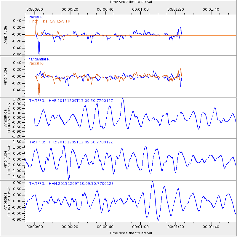
TPFO Pinon Flats, CA, USA - Earthquake Result Viewer
*The percent match for this event was below the threshold and hence no stack was calculated.
| Earthquake location: |
Fiji Islands Region |
| Earthquake latitude/longitude: |
-16.6/175.3 |
| Earthquake time(UTC): |
2015/12/09 (343) 12:58:01 GMT |
| Earthquake Depth: |
10 km |
| Earthquake Magnitude: |
5.7 MB |
| Earthquake Catalog/Contributor: |
NEIC PDE/NEIC COMCAT |
|
| Network: |
TA USArray Transportable Network (new EarthScope stations) |
| Station: |
TPFO Pinon Flats, CA, USA |
| Lat/Lon: |
33.61 N/116.45 W |
| Elevation: |
1275 m |
|
| Distance: |
82.0 deg |
| Az: |
51.531 deg |
| Baz: |
244.087 deg |
| Ray Param: |
$rayparam |
*The percent match for this event was below the threshold and hence was not used in the summary stack. |
|
| Radial Match: |
71.56583 % |
| Radial Bump: |
318 |
| Transverse Match: |
46.802456 % |
| Transverse Bump: |
349 |
| SOD ConfigId: |
7422571 |
| Insert Time: |
2019-04-21 14:15:46.232 +0000 |
| GWidth: |
2.5 |
| Max Bumps: |
400 |
| Tol: |
0.001 |
|
Signal To Noise
| Channel | StoN | STA | LTA |
| TA:TPFO: :HHZ:20151209T13:09:50.770012Z | 1.6727625 | 6.916085E-7 | 4.1345288E-7 |
| TA:TPFO: :HHN:20151209T13:09:50.770012Z | 0.8302462 | 3.0880594E-7 | 3.7194502E-7 |
| TA:TPFO: :HHE:20151209T13:09:50.770012Z | 2.1487663 | 5.751582E-7 | 2.6766907E-7 |
| Arrivals |
| Ps | |
| PpPs | |
| PsPs/PpSs | |


