You are here: Home > Network List > IC - New China Digital Seismograph Network Stations List
> Station LSA Tibet, China > Earthquake Result Viewer
LSA Tibet, China - Earthquake Result Viewer
| Earthquake location: |
Banda Sea |
| Earthquake latitude/longitude: |
-6.9/128.9 |
| Earthquake time(UTC): |
1995/09/18 (261) 06:56:31 GMT |
| Earthquake Depth: |
180 km |
| Earthquake Magnitude: |
5.5 MB |
| Earthquake Catalog/Contributor: |
WHDF/NEIC |
|
| Network: |
IC New China Digital Seismograph Network |
| Station: |
LSA Tibet, China |
| Lat/Lon: |
29.70 N/91.15 E |
| Elevation: |
3789 m |
|
| Distance: |
51.4 deg |
| Az: |
317.045 deg |
| Baz: |
128.966 deg |
| Ray Param: |
0.066794746 |
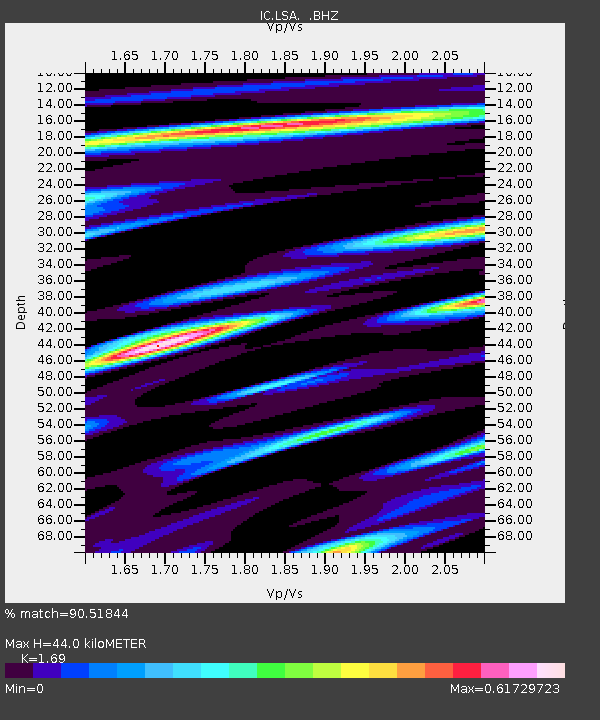
| Estimated Moho Depth: |
44.0 km |
| Estimated Crust Vp/Vs: |
1.69 |
| Assumed Crust Vp: |
6.514 km/s |
| Estimated Crust Vs: |
3.855 km/s |
| Estimated Crust Poisson's Ratio: |
0.23 |
|
| Radial Match: |
90.51844 % |
| Radial Bump: |
400 |
| Transverse Match: |
79.11312 % |
| Transverse Bump: |
400 |
| SOD ConfigId: |
4480 |
| Insert Time: |
2010-03-04 22:42:41.168 +0000 |
| GWidth: |
2.5 |
| Max Bumps: |
400 |
| Tol: |
0.001 |
|
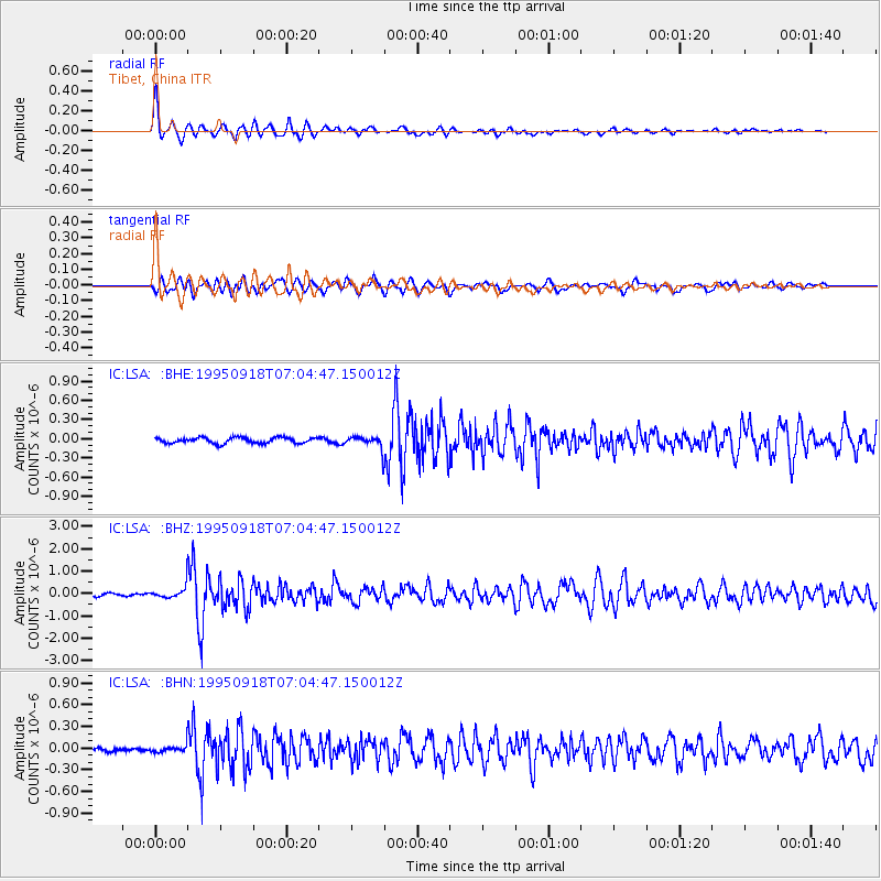
Signal To Noise
| Channel | StoN | STA | LTA |
| IC:LSA: :BHZ:19950918T07:04:47.150012Z | 3.889584 | 3.0043168E-7 | 7.724006E-8 |
| IC:LSA: :BHN:19950918T07:04:47.150012Z | 2.5912006 | 5.917713E-8 | 2.2837726E-8 |
| IC:LSA: :BHE:19950918T07:04:47.150012Z | 1.8252641 | 8.102872E-8 | 4.4392877E-8 |
| Arrivals |
| Ps | 4.9 SECOND |
| PpPs | 17 SECOND |
| PsPs/PpSs | 22 SECOND |


