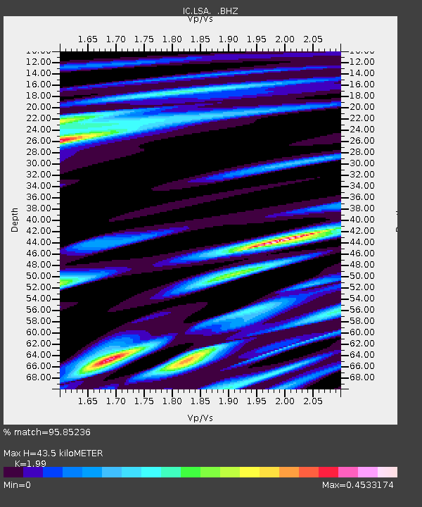
LSA Tibet, China - Earthquake Result Viewer
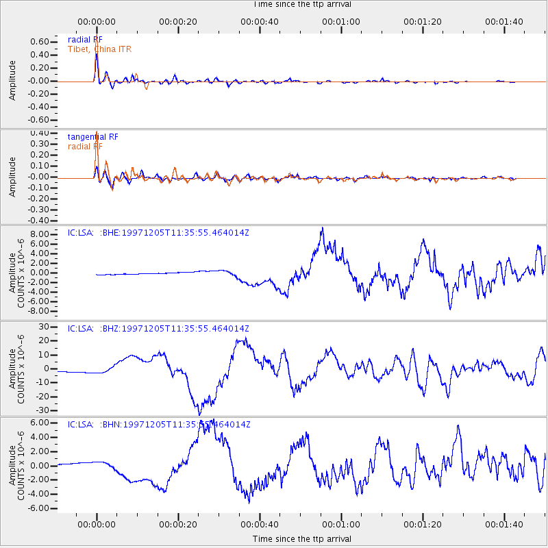
Earthquake location: Near East Coast Of Kamchatka
Earthquake latitude/longitude: 54.8/162.0
Earthquake time(UTC): 1997/12/05 (339) 11:26:54 GMT
Earthquake Depth: 33 km
Earthquake Magnitude: 6.3 MB, 7.6 MS, 7.9 UNKNOWN, 7.3 ME
Earthquake Catalog/Contributor: WHDF/NEIC
Network: IC New China Digital Seismograph Network
Station: LSA Tibet, China
Lat/Lon: 29.70 N/91.15 E
Elevation: 3789 m
Distance: 55.5 deg
Az: 273.67 deg
Baz: 41.564 deg
Ray Param: 0.06471651
Estimated Moho Depth: 43.5 km
Estimated Crust Vp/Vs: 1.99
Assumed Crust Vp: 6.514 km/s
Estimated Crust Vs: 3.274 km/s
Estimated Crust Poisson's Ratio: 0.33
Radial Match: 95.85236 %
Radial Bump: 397
Transverse Match: 89.29161 %
Transverse Bump: 400
SOD ConfigId: 4480
Insert Time: 2010-03-04 22:42:42.587 +0000
GWidth: 2.5
Max Bumps: 400
Tol: 0.001

Signal To Noise

ChannelStoNSTALTA
IC:LSA: :BHZ:19971205T11:35:55.464014Z3.30687142.1639228E-66.543716E-7
IC:LSA: :BHN:19971205T11:35:55.464014Z2.87157344.5297213E-71.5774353E-7
IC:LSA: :BHE:19971205T11:35:55.464014Z3.0499245.8130996E-71.9059819E-7
Arrivals
Ps6.9 SECOND
PpPs19 SECOND
PsPs/PpSs26 SECOND