You are here: Home > Network List > CI - Caltech Regional Seismic Network Stations List
> Station VES Vestal, Richgrove, CA, USA > Earthquake Result Viewer
VES Vestal, Richgrove, CA, USA - Earthquake Result Viewer
| Earthquake location: |
Andreanof Islands, Aleutian Is. |
| Earthquake latitude/longitude: |
51.4/-179.5 |
| Earthquake time(UTC): |
2007/12/19 (353) 09:30:27 GMT |
| Earthquake Depth: |
29 km |
| Earthquake Magnitude: |
6.4 MB, 7.1 MS, 7.1 MW, 7.0 MW |
| Earthquake Catalog/Contributor: |
WHDF/NEIC |
|
| Network: |
CI Caltech Regional Seismic Network |
| Station: |
VES Vestal, Richgrove, CA, USA |
| Lat/Lon: |
35.84 N/119.08 W |
| Elevation: |
154 m |
|
| Distance: |
45.1 deg |
| Az: |
85.697 deg |
| Baz: |
309.696 deg |
| Ray Param: |
0.0714237 |
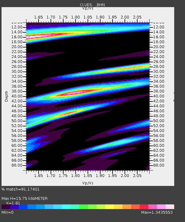
| Estimated Moho Depth: |
15.75 km |
| Estimated Crust Vp/Vs: |
1.61 |
| Assumed Crust Vp: |
6.1 km/s |
| Estimated Crust Vs: |
3.789 km/s |
| Estimated Crust Poisson's Ratio: |
0.19 |
|
| Radial Match: |
91.17401 % |
| Radial Bump: |
400 |
| Transverse Match: |
75.40366 % |
| Transverse Bump: |
400 |
| SOD ConfigId: |
2564 |
| Insert Time: |
2010-02-26 00:00:54.668 +0000 |
| GWidth: |
2.5 |
| Max Bumps: |
400 |
| Tol: |
0.001 |
|
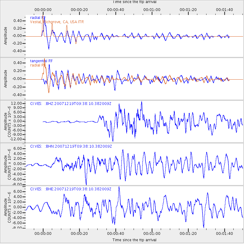
Signal To Noise
| Channel | StoN | STA | LTA |
| CI:VES: :BHN:20071219T09:38:10.382009Z | 0.86584216 | 5.396184E-7 | 6.232295E-7 |
| CI:VES: :BHE:20071219T09:38:10.382009Z | 1.9843931 | 1.3451056E-6 | 6.778423E-7 |
| CI:VES: :BHZ:20071219T09:38:10.382009Z | 7.9647374 | 2.265398E-6 | 2.8442847E-7 |
| Arrivals |
| Ps | 1.7 SECOND |
| PpPs | 6.3 SECOND |
| PsPs/PpSs | 8.0 SECOND |


