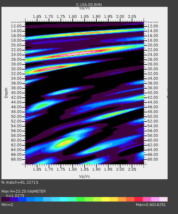
LSA Tibet, China - Earthquake Result Viewer
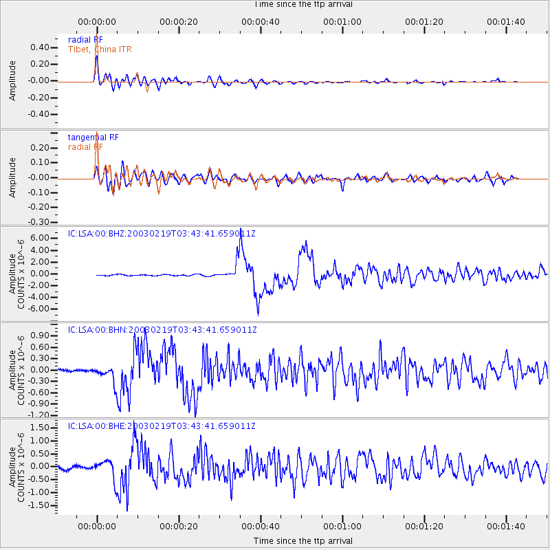
Earthquake location: Unimak Island Region, Alaska
Earthquake latitude/longitude: 53.6/-164.6
Earthquake time(UTC): 2003/02/19 (050) 03:32:36 GMT
Earthquake Depth: 19 km
Earthquake Magnitude: 5.8 MB, 6.6 MS, 6.6 MW, 6.6 MW
Earthquake Catalog/Contributor: WHDF/NEIC
Network: IC New China Digital Seismograph Network
Station: LSA Tibet, China
Lat/Lon: 29.70 N/91.15 E
Elevation: 3789 m
Distance: 74.4 deg
Az: 298.871 deg
Baz: 36.815 deg
Ray Param: 0.052342042
Estimated Moho Depth: 23.25 km
Estimated Crust Vp/Vs: 1.83
Assumed Crust Vp: 6.514 km/s
Estimated Crust Vs: 3.565 km/s
Estimated Crust Poisson's Ratio: 0.29
Radial Match: 91.32715 %
Radial Bump: 400
Transverse Match: 84.02257 %
Transverse Bump: 400
SOD ConfigId: 4714
Insert Time: 2010-03-04 22:43:13.207 +0000
GWidth: 2.5
Max Bumps: 400
Tol: 0.001

Signal To Noise

ChannelStoNSTALTA
IC:LSA:00:BHN:20030219T03:43:41.659011Z6.7902922.1959802E-73.234E-8
IC:LSA:00:BHE:20030219T03:43:41.659011Z4.20554973.88244E-79.231706E-8
IC:LSA:00:BHZ:20030219T03:43:41.659011Z15.5162851.5085595E-69.722427E-8
Arrivals
Ps3.1 SECOND
PpPs9.8 SECOND
PsPs/PpSs13 SECOND