You are here: Home > Network List > CI - Caltech Regional Seismic Network Stations List
> Station VES Vestal, Richgrove, CA, USA > Earthquake Result Viewer
VES Vestal, Richgrove, CA, USA - Earthquake Result Viewer

| Earthquake location: |
Peru-Ecuador Border Region |
| Earthquake latitude/longitude: |
-2.3/-77.8 |
| Earthquake time(UTC): |
2007/11/16 (320) 03:13:00 GMT |
| Earthquake Depth: |
123 km |
| Earthquake Magnitude: |
6.3 MB, 6.8 MW, 6.7 MW |
| Earthquake Catalog/Contributor: |
WHDF/NEIC |
|
| Network: |
CI Caltech Regional Seismic Network |
| Station: |
VES Vestal, Richgrove, CA, USA |
| Lat/Lon: |
35.84 N/119.08 W |
| Elevation: |
154 m |
|
| Distance: |
54.1 deg |
| Az: |
318.569 deg |
| Baz: |
125.536 deg |
| Ray Param: |
0.06531216 |
| Estimated Moho Depth: |
14.5 km |
| Estimated Crust Vp/Vs: |
1.60 |
| Assumed Crust Vp: |
6.1 km/s |
| Estimated Crust Vs: |
3.812 km/s |
| Estimated Crust Poisson's Ratio: |
0.18 |
|
| Radial Match: |
93.87498 % |
| Radial Bump: |
400 |
| Transverse Match: |
91.02846 % |
| Transverse Bump: |
400 |
| SOD ConfigId: |
2564 |
| Insert Time: |
2010-02-26 00:00:56.217 +0000 |
| GWidth: |
2.5 |
| Max Bumps: |
400 |
| Tol: |
0.001 |
|
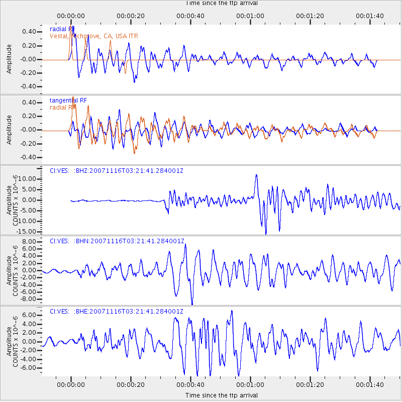
Signal To Noise
| Channel | StoN | STA | LTA |
| CI:VES: :BHN:20071116T03:21:41.284001Z | 1.1517993 | 6.15447E-7 | 5.3433524E-7 |
| CI:VES: :BHE:20071116T03:21:41.284001Z | 1.4767122 | 8.02043E-7 | 5.4312756E-7 |
| CI:VES: :BHZ:20071116T03:21:41.284001Z | 16.259043 | 2.6503142E-6 | 1.6300554E-7 |
| Arrivals |
| Ps | 1.5 SECOND |
| PpPs | 5.9 SECOND |
| PsPs/PpSs | 7.4 SECOND |


