You are here: Home > Network List > IC - New China Digital Seismograph Network Stations List
> Station LSA Tibet, China > Earthquake Result Viewer
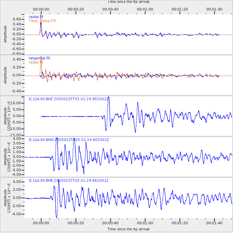
LSA Tibet, China - Earthquake Result Viewer

| Earthquake location: |
Flores Region, Indonesia |
| Earthquake latitude/longitude: |
-8.3/120.7 |
| Earthquake time(UTC): |
2003/03/25 (084) 02:53:25 GMT |
| Earthquake Depth: |
33 km |
| Earthquake Magnitude: |
6.2 MB, 6.1 MS, 6.5 MW, 6.3 MW |
| Earthquake Catalog/Contributor: |
WHDF/NEIC |
|
| Network: |
IC New China Digital Seismograph Network |
| Station: |
LSA Tibet, China |
| Lat/Lon: |
29.70 N/91.15 E |
| Elevation: |
3789 m |
|
| Distance: |
47.3 deg |
| Az: |
324.224 deg |
| Baz: |
138.319 deg |
| Ray Param: |
0.07001227 |
| Estimated Moho Depth: |
30.75 km |
| Estimated Crust Vp/Vs: |
2.06 |
| Assumed Crust Vp: |
6.514 km/s |
| Estimated Crust Vs: |
3.162 km/s |
| Estimated Crust Poisson's Ratio: |
0.35 |
|
| Radial Match: |
94.4411 % |
| Radial Bump: |
400 |
| Transverse Match: |
88.45958 % |
| Transverse Bump: |
400 |
| SOD ConfigId: |
4714 |
| Insert Time: |
2010-03-04 22:43:20.687 +0000 |
| GWidth: |
2.5 |
| Max Bumps: |
400 |
| Tol: |
0.001 |
|
Signal To Noise
| Channel | StoN | STA | LTA |
| IC:LSA:00:BHN:20030325T03:01:24.862001Z | 0.88587695 | 2.2527958E-8 | 2.5430122E-8 |
| IC:LSA:00:BHE:20030325T03:01:24.862001Z | 0.7101449 | 8.130769E-8 | 1.14494505E-7 |
| IC:LSA:00:BHZ:20030325T03:01:24.862001Z | 1.3032787 | 5.685253E-8 | 4.36227E-8 |
| Arrivals |
| Ps | 5.3 SECOND |
| PpPs | 14 SECOND |
| PsPs/PpSs | 19 SECOND |


