You are here: Home > Network List > YT07 - POLENET Stations List
> Station N140 N140 > Earthquake Result Viewer
N140 N140 - Earthquake Result Viewer
| Earthquake location: |
South Sandwich Islands Region |
| Earthquake latitude/longitude: |
-58.9/-23.9 |
| Earthquake time(UTC): |
2015/12/10 (344) 12:05:15 GMT |
| Earthquake Depth: |
10 km |
| Earthquake Magnitude: |
5.7 MWP |
| Earthquake Catalog/Contributor: |
NEIC PDE/NEIC COMCAT |
|
| Network: |
YT POLENET |
| Station: |
N140 N140 |
| Lat/Lon: |
82.01 S/96.76 E |
| Elevation: |
3570 m |
|
| Distance: |
35.9 deg |
| Az: |
168.167 deg |
| Baz: |
229.484 deg |
| Ray Param: |
0.07694789 |
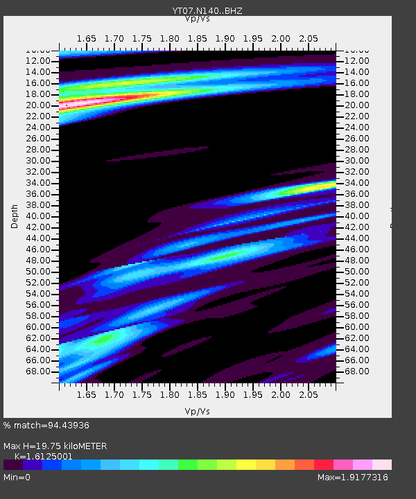
| Estimated Moho Depth: |
19.75 km |
| Estimated Crust Vp/Vs: |
1.61 |
| Assumed Crust Vp: |
6.261 km/s |
| Estimated Crust Vs: |
3.883 km/s |
| Estimated Crust Poisson's Ratio: |
0.19 |
|
| Radial Match: |
94.43936 % |
| Radial Bump: |
400 |
| Transverse Match: |
85.42582 % |
| Transverse Bump: |
400 |
| SOD ConfigId: |
7422571 |
| Insert Time: |
2019-04-21 14:27:23.367 +0000 |
| GWidth: |
2.5 |
| Max Bumps: |
400 |
| Tol: |
0.001 |
|

Signal To Noise
| Channel | StoN | STA | LTA |
| YT:N140: :BHZ:20151210T12:11:44.950006Z | 63.116966 | 6.566683E-6 | 1.04039906E-7 |
| YT:N140: :BHN:20151210T12:11:44.950006Z | 26.318382 | 1.6789023E-6 | 6.3792E-8 |
| YT:N140: :BHE:20151210T12:11:44.950006Z | 13.473388 | 1.3831012E-6 | 1.02654305E-7 |
| Arrivals |
| Ps | 2.1 SECOND |
| PpPs | 7.6 SECOND |
| PsPs/PpSs | 9.7 SECOND |


