You are here: Home > Network List > IC - New China Digital Seismograph Network Stations List
> Station LSA Tibet, China > Earthquake Result Viewer
LSA Tibet, China - Earthquake Result Viewer

| Earthquake location: |
Ryukyu Islands, Japan |
| Earthquake latitude/longitude: |
27.9/130.3 |
| Earthquake time(UTC): |
1995/10/18 (291) 10:37:26 GMT |
| Earthquake Depth: |
27 km |
| Earthquake Magnitude: |
6.5 MB, 6.8 MS, 6.7 UNKNOWN, 7.1 MW |
| Earthquake Catalog/Contributor: |
WHDF/NEIC |
|
| Network: |
IC New China Digital Seismograph Network |
| Station: |
LSA Tibet, China |
| Lat/Lon: |
29.70 N/91.15 E |
| Elevation: |
3789 m |
|
| Distance: |
34.3 deg |
| Az: |
282.522 deg |
| Baz: |
83.151 deg |
| Ray Param: |
0.07778384 |
| Estimated Moho Depth: |
42.75 km |
| Estimated Crust Vp/Vs: |
2.10 |
| Assumed Crust Vp: |
6.514 km/s |
| Estimated Crust Vs: |
3.106 km/s |
| Estimated Crust Poisson's Ratio: |
0.35 |
|
| Radial Match: |
91.98268 % |
| Radial Bump: |
393 |
| Transverse Match: |
78.33864 % |
| Transverse Bump: |
400 |
| SOD ConfigId: |
4480 |
| Insert Time: |
2010-03-04 22:43:31.797 +0000 |
| GWidth: |
2.5 |
| Max Bumps: |
400 |
| Tol: |
0.001 |
|
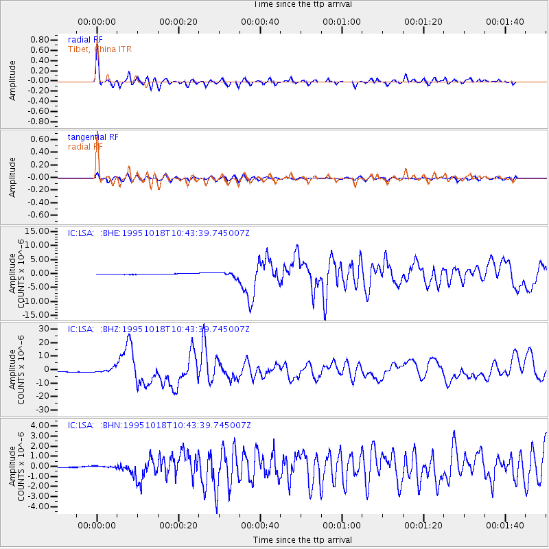
Signal To Noise
| Channel | StoN | STA | LTA |
| IC:LSA: :BHZ:19951018T10:43:39.745007Z | 7.3389406 | 1.8426871E-6 | 2.5108352E-7 |
| IC:LSA: :BHN:19951018T10:43:39.745007Z | 2.7870512 | 9.899067E-8 | 3.5518067E-8 |
| IC:LSA: :BHE:19951018T10:43:39.745007Z | 7.2682867 | 8.332321E-7 | 1.14639406E-7 |
| Arrivals |
| Ps | 7.7 SECOND |
| PpPs | 19 SECOND |
| PsPs/PpSs | 27 SECOND |


