You are here: Home > Network List > AZ - ANZA Regional Network Stations List
> Station LVA2 AZ.LVA2 > Earthquake Result Viewer
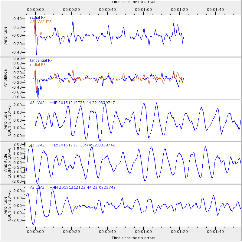
LVA2 AZ.LVA2 - Earthquake Result Viewer
*The percent match for this event was below the threshold and hence no stack was calculated.
| Earthquake location: |
Southeast Of Easter Island |
| Earthquake latitude/longitude: |
-41.1/-90.1 |
| Earthquake time(UTC): |
2015/12/12 (346) 23:32:54 GMT |
| Earthquake Depth: |
10 km |
| Earthquake Magnitude: |
5.5 mwb |
| Earthquake Catalog/Contributor: |
NEIC PDE/us |
|
| Network: |
AZ ANZA Regional Network |
| Station: |
LVA2 AZ.LVA2 |
| Lat/Lon: |
33.35 N/116.56 W |
| Elevation: |
1435 m |
|
| Distance: |
78.0 deg |
| Az: |
337.563 deg |
| Baz: |
159.844 deg |
| Ray Param: |
$rayparam |
*The percent match for this event was below the threshold and hence was not used in the summary stack. |
|
| Radial Match: |
34.760345 % |
| Radial Bump: |
400 |
| Transverse Match: |
84.332016 % |
| Transverse Bump: |
400 |
| SOD ConfigId: |
7422571 |
| Insert Time: |
2019-04-21 14:28:22.473 +0000 |
| GWidth: |
2.5 |
| Max Bumps: |
400 |
| Tol: |
0.001 |
|
Signal To Noise
| Channel | StoN | STA | LTA |
| AZ:LVA2: :HHZ:20151212T23:44:22.032974Z | 1.090821 | 1.2492235E-6 | 1.1452139E-6 |
| AZ:LVA2: :HHN:20151212T23:44:22.032974Z | 2.0316045 | 1.7437769E-6 | 8.5832494E-7 |
| AZ:LVA2: :HHE:20151212T23:44:22.032974Z | 1.1505653 | 1.0645321E-6 | 9.2522527E-7 |
| Arrivals |
| Ps | |
| PpPs | |
| PsPs/PpSs | |


