You are here: Home > Network List > CI - Caltech Regional Seismic Network Stations List
> Station VES Vestal, Richgrove, CA, USA > Earthquake Result Viewer
VES Vestal, Richgrove, CA, USA - Earthquake Result Viewer
| Earthquake location: |
Mariana Islands |
| Earthquake latitude/longitude: |
18.9/145.4 |
| Earthquake time(UTC): |
2007/10/31 (304) 03:30:17 GMT |
| Earthquake Depth: |
223 km |
| Earthquake Magnitude: |
6.2 MB, 7.2 MW, 7.2 MW |
| Earthquake Catalog/Contributor: |
WHDF/NEIC |
|
| Network: |
CI Caltech Regional Seismic Network |
| Station: |
VES Vestal, Richgrove, CA, USA |
| Lat/Lon: |
35.84 N/119.08 W |
| Elevation: |
154 m |
|
| Distance: |
83.5 deg |
| Az: |
54.482 deg |
| Baz: |
288.481 deg |
| Ray Param: |
0.045601167 |
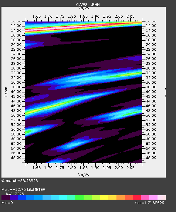
| Estimated Moho Depth: |
12.75 km |
| Estimated Crust Vp/Vs: |
1.73 |
| Assumed Crust Vp: |
6.1 km/s |
| Estimated Crust Vs: |
3.531 km/s |
| Estimated Crust Poisson's Ratio: |
0.25 |
|
| Radial Match: |
85.48843 % |
| Radial Bump: |
359 |
| Transverse Match: |
74.66131 % |
| Transverse Bump: |
397 |
| SOD ConfigId: |
2564 |
| Insert Time: |
2010-02-26 00:00:58.015 +0000 |
| GWidth: |
2.5 |
| Max Bumps: |
400 |
| Tol: |
0.001 |
|
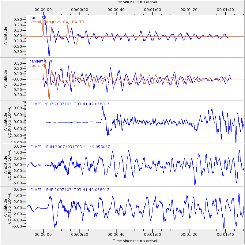
Signal To Noise
| Channel | StoN | STA | LTA |
| CI:VES: :BHN:20071031T03:41:49.05801Z | 0.43483415 | 2.702479E-7 | 6.2149644E-7 |
| CI:VES: :BHE:20071031T03:41:49.05801Z | 2.8891237 | 1.846821E-6 | 6.392322E-7 |
| CI:VES: :BHZ:20071031T03:41:49.05801Z | 20.791492 | 4.3209975E-6 | 2.0782527E-7 |
| Arrivals |
| Ps | 1.6 SECOND |
| PpPs | 5.6 SECOND |
| PsPs/PpSs | 7.1 SECOND |


