You are here: Home > Network List > IC - New China Digital Seismograph Network Stations List
> Station LSA Tibet, China > Earthquake Result Viewer
LSA Tibet, China - Earthquake Result Viewer
| Earthquake location: |
Kamchatka Peninsula, Russia |
| Earthquake latitude/longitude: |
55.7/160.0 |
| Earthquake time(UTC): |
2004/06/10 (162) 15:19:57 GMT |
| Earthquake Depth: |
189 km |
| Earthquake Magnitude: |
6.1 MB, 6.9 MW, 6.9 MW |
| Earthquake Catalog/Contributor: |
WHDF/NEIC |
|
| Network: |
IC New China Digital Seismograph Network |
| Station: |
LSA Tibet, China |
| Lat/Lon: |
29.70 N/91.15 E |
| Elevation: |
3789 m |
|
| Distance: |
54.3 deg |
| Az: |
271.447 deg |
| Baz: |
40.598 deg |
| Ray Param: |
0.06491385 |
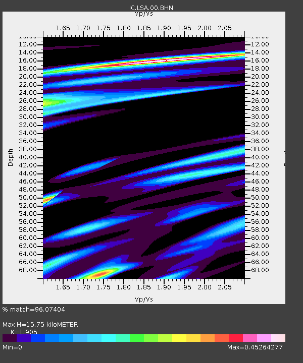
| Estimated Moho Depth: |
15.75 km |
| Estimated Crust Vp/Vs: |
1.90 |
| Assumed Crust Vp: |
6.514 km/s |
| Estimated Crust Vs: |
3.42 km/s |
| Estimated Crust Poisson's Ratio: |
0.31 |
|
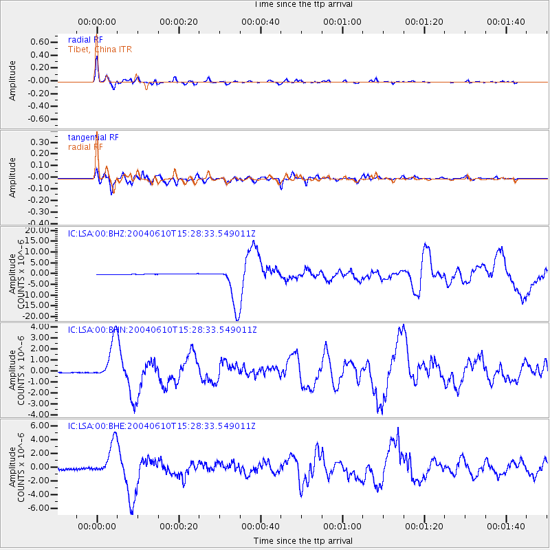
| Radial Match: |
96.07404 % |
| Radial Bump: |
349 |
| Transverse Match: |
93.87068 % |
| Transverse Bump: |
400 |
| SOD ConfigId: |
2459 |
| Insert Time: |
2010-03-04 22:43:47.645 +0000 |
| GWidth: |
2.5 |
| Max Bumps: |
400 |
| Tol: |
0.001 |
|
Signal To Noise
| Channel | StoN | STA | LTA |
| IC:LSA:00:BHN:20040610T15:28:33.549011Z | 34.341022 | 1.947595E-6 | 5.6713365E-8 |
| IC:LSA:00:BHE:20040610T15:28:33.549011Z | 22.207293 | 2.5685238E-6 | 1.1566128E-7 |
| IC:LSA:00:BHZ:20040610T15:28:33.549011Z | 70.40346 | 1.05475765E-5 | 1.4981617E-7 |
| Arrivals |
| Ps | 2.3 SECOND |
| PpPs | 6.7 SECOND |
| PsPs/PpSs | 9.0 SECOND |


