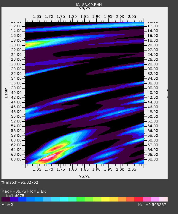
LSA Tibet, China - Earthquake Result Viewer
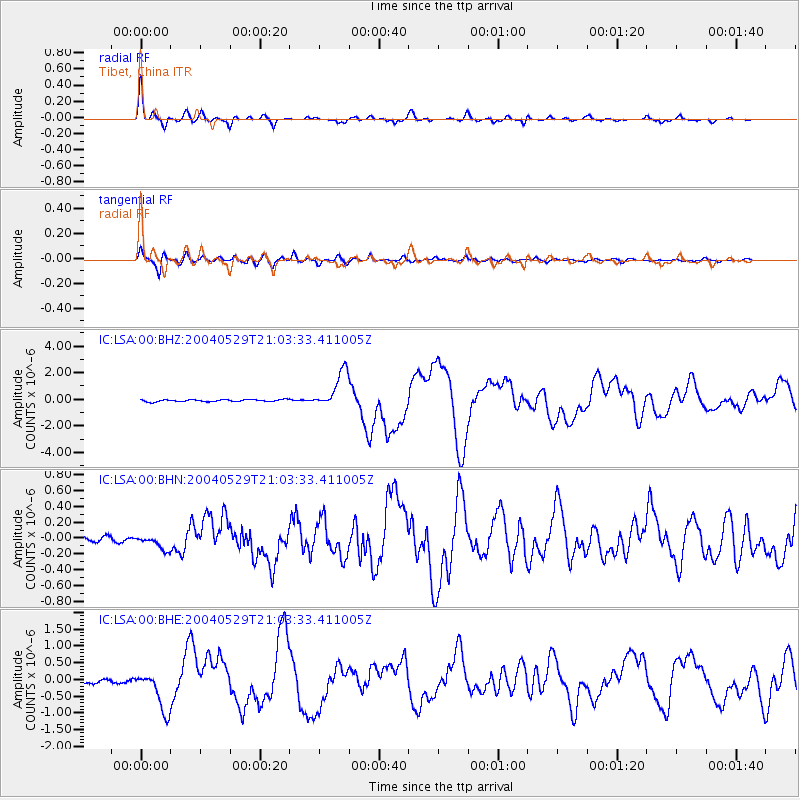
Earthquake location: Off East Coast Of Honshu, Japan
Earthquake latitude/longitude: 34.3/141.4
Earthquake time(UTC): 2004/05/29 (150) 20:56:09 GMT
Earthquake Depth: 16 km
Earthquake Magnitude: 5.6 MB, 6.6 MS, 6.5 MW, 6.3 MW
Earthquake Catalog/Contributor: WHDF/NEIC
Network: IC New China Digital Seismograph Network
Station: LSA Tibet, China
Lat/Lon: 29.70 N/91.15 E
Elevation: 3789 m
Distance: 42.5 deg
Az: 278.223 deg
Baz: 70.434 deg
Ray Param: 0.07310865
Estimated Moho Depth: 66.75 km
Estimated Crust Vp/Vs: 1.70
Assumed Crust Vp: 6.514 km/s
Estimated Crust Vs: 3.838 km/s
Estimated Crust Poisson's Ratio: 0.23
Radial Match: 93.62702 %
Radial Bump: 335
Transverse Match: 86.74235 %
Transverse Bump: 400
SOD ConfigId: 2459
Insert Time: 2010-03-04 22:43:48.786 +0000
GWidth: 2.5
Max Bumps: 400
Tol: 0.001

Signal To Noise

ChannelStoNSTALTA
IC:LSA:00:BHN:20040529T21:03:33.411005Z2.8418828.744812E-83.07712E-8
IC:LSA:00:BHE:20040529T21:03:33.411005Z7.3280376.2007314E-78.461654E-8
IC:LSA:00:BHZ:20040529T21:03:33.411005Z18.3634361.4017693E-67.633481E-8
Arrivals
Ps7.7 SECOND
PpPs26 SECOND
PsPs/PpSs33 SECOND