You are here: Home > Network List > TA - USArray Transportable Network (new EarthScope stations) Stations List
> Station 435B Jarrell, TX, USA > Earthquake Result Viewer
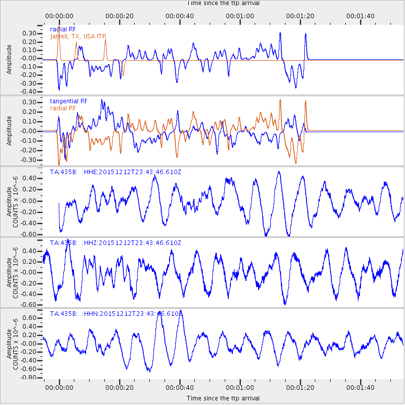
435B Jarrell, TX, USA - Earthquake Result Viewer
*The percent match for this event was below the threshold and hence no stack was calculated.
| Earthquake location: |
Southeast Of Easter Island |
| Earthquake latitude/longitude: |
-41.1/-90.1 |
| Earthquake time(UTC): |
2015/12/12 (346) 23:32:54 GMT |
| Earthquake Depth: |
10 km |
| Earthquake Magnitude: |
5.5 mwb |
| Earthquake Catalog/Contributor: |
NEIC PDE/us |
|
| Network: |
TA USArray Transportable Network (new EarthScope stations) |
| Station: |
435B Jarrell, TX, USA |
| Lat/Lon: |
30.78 N/97.58 W |
| Elevation: |
248 m |
|
| Distance: |
71.9 deg |
| Az: |
353.198 deg |
| Baz: |
174.031 deg |
| Ray Param: |
$rayparam |
*The percent match for this event was below the threshold and hence was not used in the summary stack. |
|
| Radial Match: |
44.962975 % |
| Radial Bump: |
400 |
| Transverse Match: |
65.510315 % |
| Transverse Bump: |
400 |
| SOD ConfigId: |
7422571 |
| Insert Time: |
2019-04-21 14:33:18.463 +0000 |
| GWidth: |
2.5 |
| Max Bumps: |
400 |
| Tol: |
0.001 |
|
Signal To Noise
| Channel | StoN | STA | LTA |
| TA:435B: :HHZ:20151212T23:43:46.610Z | 2.225523 | 3.4093196E-7 | 1.5319183E-7 |
| TA:435B: :HHN:20151212T23:43:46.610Z | 0.50311464 | 1.2746331E-7 | 2.5334845E-7 |
| TA:435B: :HHE:20151212T23:43:46.610Z | 1.5656477 | 2.9297888E-7 | 1.8712952E-7 |
| Arrivals |
| Ps | |
| PpPs | |
| PsPs/PpSs | |


