You are here: Home > Network List > US - United States National Seismic Network Stations List
> Station WUAZ Wupatki, Arizona, USA > Earthquake Result Viewer
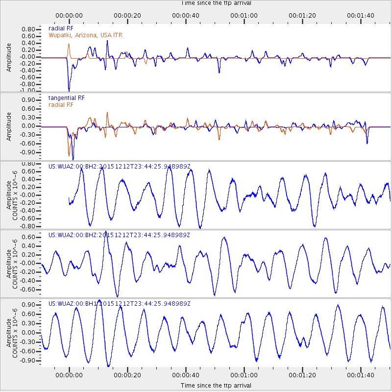
WUAZ Wupatki, Arizona, USA - Earthquake Result Viewer
*The percent match for this event was below the threshold and hence no stack was calculated.
| Earthquake location: |
Southeast Of Easter Island |
| Earthquake latitude/longitude: |
-41.1/-90.1 |
| Earthquake time(UTC): |
2015/12/12 (346) 23:32:54 GMT |
| Earthquake Depth: |
10 km |
| Earthquake Magnitude: |
5.5 mwb |
| Earthquake Catalog/Contributor: |
NEIC PDE/us |
|
| Network: |
US United States National Seismic Network |
| Station: |
WUAZ Wupatki, Arizona, USA |
| Lat/Lon: |
35.52 N/111.37 W |
| Elevation: |
1592 m |
|
| Distance: |
78.7 deg |
| Az: |
342.409 deg |
| Baz: |
163.744 deg |
| Ray Param: |
$rayparam |
*The percent match for this event was below the threshold and hence was not used in the summary stack. |
|
| Radial Match: |
63.494137 % |
| Radial Bump: |
400 |
| Transverse Match: |
64.063034 % |
| Transverse Bump: |
400 |
| SOD ConfigId: |
7422571 |
| Insert Time: |
2019-04-21 14:33:55.628 +0000 |
| GWidth: |
2.5 |
| Max Bumps: |
400 |
| Tol: |
0.001 |
|
Signal To Noise
| Channel | StoN | STA | LTA |
| US:WUAZ:00:BHZ:20151212T23:44:25.948989Z | 0.42037442 | 8.840417E-8 | 2.1029865E-7 |
| US:WUAZ:00:BH1:20151212T23:44:25.948989Z | 1.8224363 | 5.5874744E-7 | 3.0659368E-7 |
| US:WUAZ:00:BH2:20151212T23:44:25.948989Z | 1.177386 | 4.5849995E-7 | 3.8942196E-7 |
| Arrivals |
| Ps | |
| PpPs | |
| PsPs/PpSs | |


