You are here: Home > Network List > IC - New China Digital Seismograph Network Stations List
> Station LSA Tibet, China > Earthquake Result Viewer
LSA Tibet, China - Earthquake Result Viewer
| Earthquake location: |
South Indian Ocean |
| Earthquake latitude/longitude: |
-36.7/53.4 |
| Earthquake time(UTC): |
2004/01/11 (011) 04:32:47 GMT |
| Earthquake Depth: |
5.3 km |
| Earthquake Magnitude: |
6.1 MB, 6.1 MS, 6.2 MW, 6.2 MW |
| Earthquake Catalog/Contributor: |
WHDF/NEIC |
|
| Network: |
IC New China Digital Seismograph Network |
| Station: |
LSA Tibet, China |
| Lat/Lon: |
29.70 N/91.15 E |
| Elevation: |
3789 m |
|
| Distance: |
75.0 deg |
| Az: |
33.513 deg |
| Baz: |
210.666 deg |
| Ray Param: |
0.051982734 |
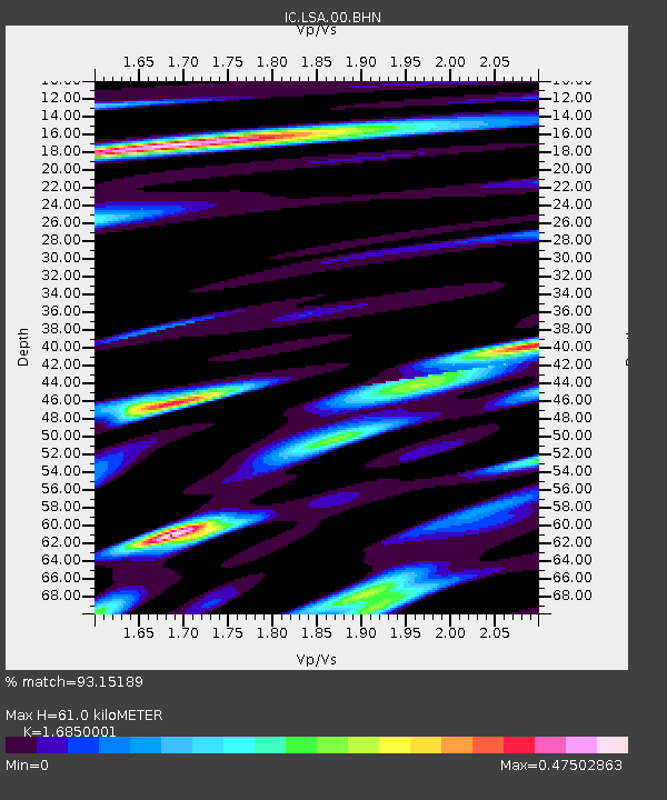
| Estimated Moho Depth: |
61.0 km |
| Estimated Crust Vp/Vs: |
1.69 |
| Assumed Crust Vp: |
6.514 km/s |
| Estimated Crust Vs: |
3.866 km/s |
| Estimated Crust Poisson's Ratio: |
0.23 |
|
| Radial Match: |
93.15189 % |
| Radial Bump: |
400 |
| Transverse Match: |
87.67483 % |
| Transverse Bump: |
400 |
| SOD ConfigId: |
7314 |
| Insert Time: |
2010-03-04 22:44:01.901 +0000 |
| GWidth: |
2.5 |
| Max Bumps: |
400 |
| Tol: |
0.001 |
|
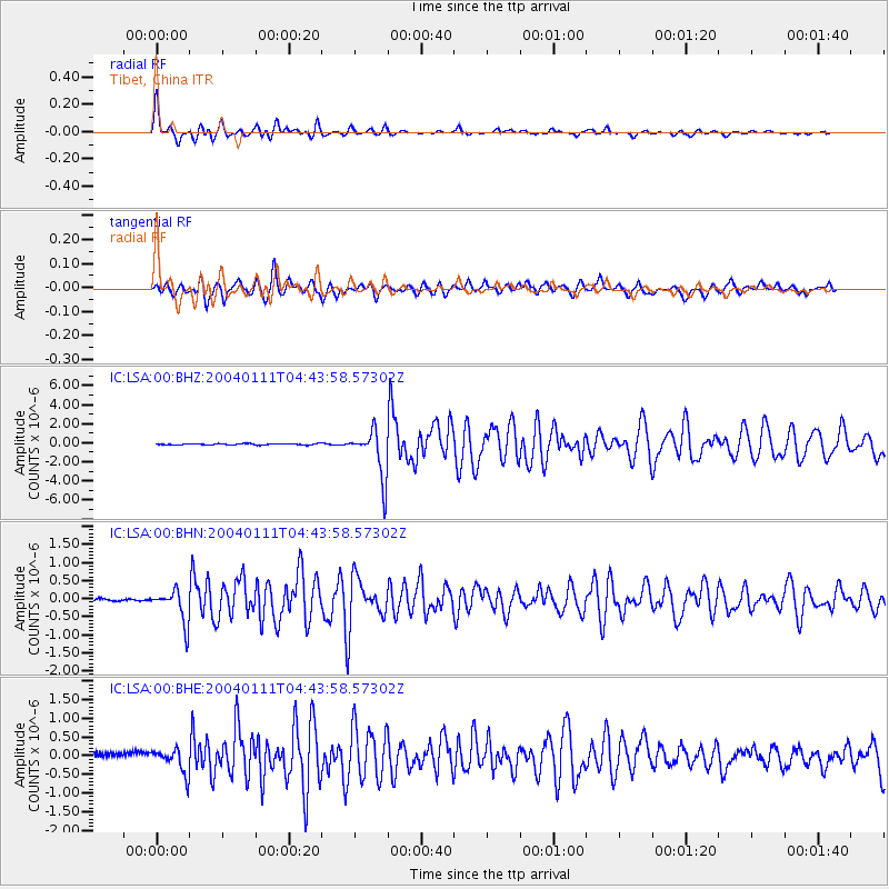
Signal To Noise
| Channel | StoN | STA | LTA |
| IC:LSA:00:BHN:20040111T04:43:58.57302Z | 19.663614 | 4.5848077E-7 | 2.33162E-8 |
| IC:LSA:00:BHE:20040111T04:43:58.57302Z | 3.4557292 | 3.2616293E-7 | 9.4383246E-8 |
| IC:LSA:00:BHZ:20040111T04:43:58.57302Z | 37.120544 | 2.551781E-6 | 6.87431E-8 |
| Arrivals |
| Ps | 6.6 SECOND |
| PpPs | 24 SECOND |
| PsPs/PpSs | 31 SECOND |


