You are here: Home > Network List > IC - New China Digital Seismograph Network Stations List
> Station LSA Tibet, China > Earthquake Result Viewer
LSA Tibet, China - Earthquake Result Viewer
| Earthquake location: |
Seram, Indonesia |
| Earthquake latitude/longitude: |
-3.1/127.4 |
| Earthquake time(UTC): |
2004/01/28 (028) 22:15:30 GMT |
| Earthquake Depth: |
17 km |
| Earthquake Magnitude: |
6.0 MB, 6.5 MS, 6.7 MW, 6.6 MW |
| Earthquake Catalog/Contributor: |
WHDF/NEIC |
|
| Network: |
IC New China Digital Seismograph Network |
| Station: |
LSA Tibet, China |
| Lat/Lon: |
29.70 N/91.15 E |
| Elevation: |
3789 m |
|
| Distance: |
47.6 deg |
| Az: |
315.86 deg |
| Baz: |
126.942 deg |
| Ray Param: |
0.06985077 |
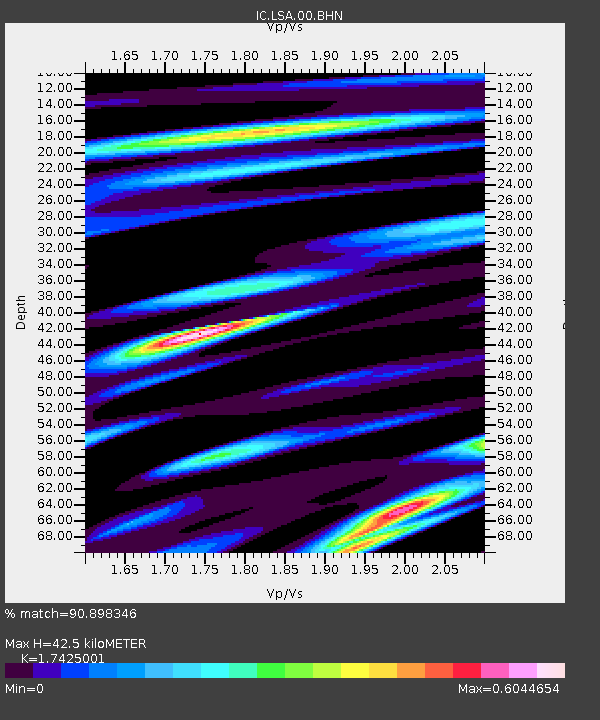
| Estimated Moho Depth: |
42.5 km |
| Estimated Crust Vp/Vs: |
1.74 |
| Assumed Crust Vp: |
6.514 km/s |
| Estimated Crust Vs: |
3.738 km/s |
| Estimated Crust Poisson's Ratio: |
0.25 |
|
| Radial Match: |
90.898346 % |
| Radial Bump: |
400 |
| Transverse Match: |
75.77823 % |
| Transverse Bump: |
400 |
| SOD ConfigId: |
2459 |
| Insert Time: |
2010-03-04 22:44:04.168 +0000 |
| GWidth: |
2.5 |
| Max Bumps: |
400 |
| Tol: |
0.001 |
|
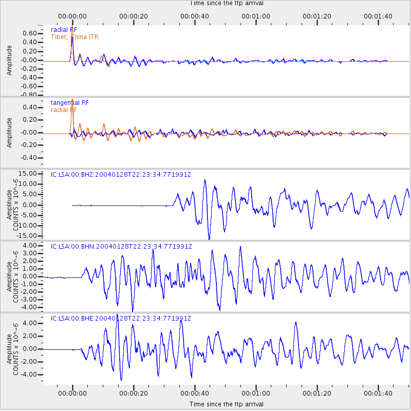
Signal To Noise
| Channel | StoN | STA | LTA |
| IC:LSA:00:BHN:20040128T22:23:34.771991Z | 17.566908 | 4.5459598E-7 | 2.5877972E-8 |
| IC:LSA:00:BHE:20040128T22:23:34.771991Z | 18.736166 | 5.7054655E-7 | 3.045162E-8 |
| IC:LSA:00:BHZ:20040128T22:23:34.771991Z | 32.664425 | 2.0216344E-6 | 6.189101E-8 |
| Arrivals |
| Ps | 5.2 SECOND |
| PpPs | 17 SECOND |
| PsPs/PpSs | 22 SECOND |


