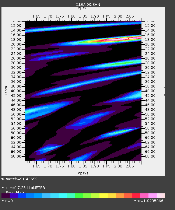
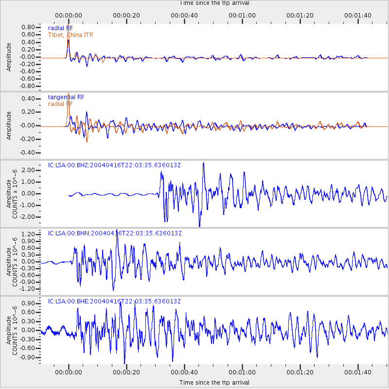
LSA Tibet, China - Earthquake Result Viewer

Earthquake location: Southern Sumatra, Indonesia
Earthquake latitude/longitude: -5.2/102.7
Earthquake time(UTC): 2004/04/16 (107) 21:57:05 GMT
Earthquake Depth: 44 km
Earthquake Magnitude: 5.6 MB, 5.8 MS, 6.0 MW, 6.0 MW
Earthquake Catalog/Contributor: WHDF/NEIC
Network: IC New China Digital Seismograph Network
Station: LSA Tibet, China
Lat/Lon: 29.70 N/91.15 E
Elevation: 3789 m
Distance: 36.4 deg
Az: 342.921 deg
Baz: 160.356 deg
Ray Param: 0.076571636
Estimated Moho Depth: 17.25 km
Estimated Crust Vp/Vs: 2.04
Assumed Crust Vp: 6.514 km/s
Estimated Crust Vs: 3.189 km/s
Estimated Crust Poisson's Ratio: 0.34
Radial Match: 91.43699 %
Radial Bump: 400
Transverse Match: 88.12527 %
Transverse Bump: 400
SOD ConfigId: 2459
Insert Time: 2010-03-04 22:44:13.521 +0000
GWidth: 2.5
Max Bumps: 400
Tol: 0.001

Signal To Noise

ChannelStoNSTALTA
IC:LSA:00:BHN:20040416T22:03:35.636013Z16.4163954.1163048E-72.5074355E-8
IC:LSA:00:BHE:20040416T22:03:35.636013Z2.95564082.565224E-78.67908E-8
IC:LSA:00:BHZ:20040416T22:03:35.636013Z14.844851.1008513E-67.4157114E-8
Arrivals
Ps2.9 SECOND
PpPs7.5 SECOND
PsPs/PpSs10 SECOND