You are here: Home > Network List > IC - New China Digital Seismograph Network Stations List
> Station LSA Tibet, China > Earthquake Result Viewer
LSA Tibet, China - Earthquake Result Viewer

| Earthquake location: |
Savu Sea |
| Earthquake latitude/longitude: |
-9.4/122.8 |
| Earthquake time(UTC): |
2004/04/23 (114) 01:50:30 GMT |
| Earthquake Depth: |
66 km |
| Earthquake Magnitude: |
6.5 MB, 6.7 MW, 6.7 MW |
| Earthquake Catalog/Contributor: |
WHDF/NEIC |
|
| Network: |
IC New China Digital Seismograph Network |
| Station: |
LSA Tibet, China |
| Lat/Lon: |
29.70 N/91.15 E |
| Elevation: |
3789 m |
|
| Distance: |
49.4 deg |
| Az: |
322.982 deg |
| Baz: |
136.93 deg |
| Ray Param: |
0.06854608 |
| Estimated Moho Depth: |
43.5 km |
| Estimated Crust Vp/Vs: |
1.70 |
| Assumed Crust Vp: |
6.514 km/s |
| Estimated Crust Vs: |
3.838 km/s |
| Estimated Crust Poisson's Ratio: |
0.23 |
|
| Radial Match: |
91.83907 % |
| Radial Bump: |
400 |
| Transverse Match: |
78.372345 % |
| Transverse Bump: |
400 |
| SOD ConfigId: |
2459 |
| Insert Time: |
2010-03-04 22:44:15.743 +0000 |
| GWidth: |
2.5 |
| Max Bumps: |
400 |
| Tol: |
0.001 |
|
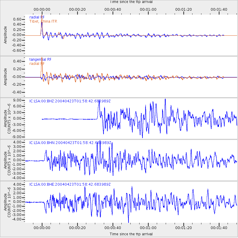
Signal To Noise
| Channel | StoN | STA | LTA |
| IC:LSA:00:BHN:20040423T01:58:42.683989Z | 28.896362 | 9.3924365E-7 | 3.2503873E-8 |
| IC:LSA:00:BHE:20040423T01:58:42.683989Z | 9.420393 | 8.8360883E-7 | 9.379745E-8 |
| IC:LSA:00:BHZ:20040423T01:58:42.683989Z | 44.88647 | 3.6471304E-6 | 8.125233E-8 |
| Arrivals |
| Ps | 5.0 SECOND |
| PpPs | 17 SECOND |
| PsPs/PpSs | 22 SECOND |


