You are here: Home > Network List > AV - Alaska Volcano Observatory Stations List
> Station SPCN Ckakachatna North Broadband, Mount Spurr, Alaska > Earthquake Result Viewer
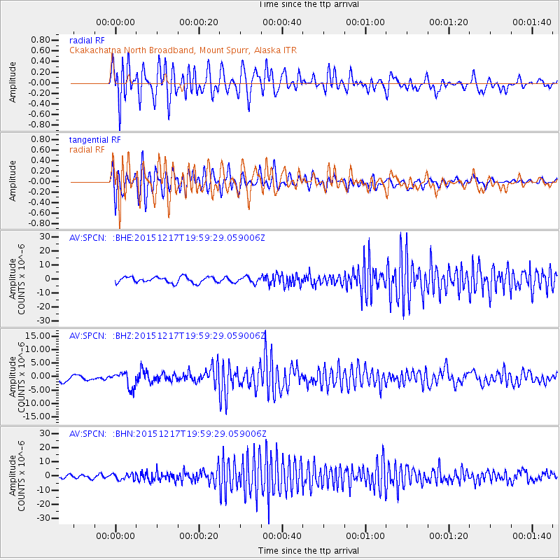
SPCN Ckakachatna North Broadband, Mount Spurr, Alaska - Earthquake Result Viewer
*The percent match for this event was below the threshold and hence no stack was calculated.
| Earthquake location: |
Near Coast Of Chiapas, Mexico |
| Earthquake latitude/longitude: |
15.9/-93.4 |
| Earthquake time(UTC): |
2015/12/17 (351) 19:49:54 GMT |
| Earthquake Depth: |
97 km |
| Earthquake Magnitude: |
6.4 MWB, 6.6 MI |
| Earthquake Catalog/Contributor: |
NEIC PDE/NEIC COMCAT |
|
| Network: |
AV Alaska Volcano Observatory |
| Station: |
SPCN Ckakachatna North Broadband, Mount Spurr, Alaska |
| Lat/Lon: |
61.22 N/152.19 W |
| Elevation: |
735 m |
|
| Distance: |
61.3 deg |
| Az: |
331.871 deg |
| Baz: |
110.349 deg |
| Ray Param: |
$rayparam |
*The percent match for this event was below the threshold and hence was not used in the summary stack. |
|
| Radial Match: |
77.69015 % |
| Radial Bump: |
400 |
| Transverse Match: |
73.89507 % |
| Transverse Bump: |
400 |
| SOD ConfigId: |
7422571 |
| Insert Time: |
2019-04-21 14:36:50.353 +0000 |
| GWidth: |
2.5 |
| Max Bumps: |
400 |
| Tol: |
0.001 |
|
Signal To Noise
| Channel | StoN | STA | LTA |
| AV:SPCN: :BHZ:20151217T19:59:29.059006Z | 2.5224533 | 3.0045985E-6 | 1.1911415E-6 |
| AV:SPCN: :BHN:20151217T19:59:29.059006Z | 1.310232 | 2.1096635E-6 | 1.6101449E-6 |
| AV:SPCN: :BHE:20151217T19:59:29.059006Z | 1.0995226 | 2.2919146E-6 | 2.0844634E-6 |
| Arrivals |
| Ps | |
| PpPs | |
| PsPs/PpSs | |


