You are here: Home > Network List > C1 - Red Sismologica Nacional Stations List
> Station MG05 Puerto Natales > Earthquake Result Viewer
MG05 Puerto Natales - Earthquake Result Viewer
| Earthquake location: |
Near Coast Of Chiapas, Mexico |
| Earthquake latitude/longitude: |
15.9/-93.4 |
| Earthquake time(UTC): |
2015/12/17 (351) 19:49:54 GMT |
| Earthquake Depth: |
97 km |
| Earthquake Magnitude: |
6.4 MWB, 6.6 MI |
| Earthquake Catalog/Contributor: |
NEIC PDE/NEIC COMCAT |
|
| Network: |
C1 Red Sismologica Nacional |
| Station: |
MG05 Puerto Natales |
| Lat/Lon: |
51.68 S/72.50 W |
| Elevation: |
99 m |
|
| Distance: |
69.7 deg |
| Az: |
166.285 deg |
| Baz: |
338.506 deg |
| Ray Param: |
0.055219807 |
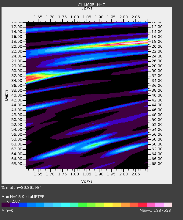
| Estimated Moho Depth: |
18.0 km |
| Estimated Crust Vp/Vs: |
2.07 |
| Assumed Crust Vp: |
6.438 km/s |
| Estimated Crust Vs: |
3.11 km/s |
| Estimated Crust Poisson's Ratio: |
0.35 |
|
| Radial Match: |
86.361984 % |
| Radial Bump: |
378 |
| Transverse Match: |
73.57835 % |
| Transverse Bump: |
400 |
| SOD ConfigId: |
7422571 |
| Insert Time: |
2019-04-21 14:37:19.813 +0000 |
| GWidth: |
2.5 |
| Max Bumps: |
400 |
| Tol: |
0.001 |
|

Signal To Noise
| Channel | StoN | STA | LTA |
| C1:MG05: :HHZ:20151217T20:00:22.699021Z | 10.532672 | 5.189921E-6 | 4.9274496E-7 |
| C1:MG05: :HHN:20151217T20:00:22.699021Z | 5.349658 | 1.797058E-6 | 3.3592016E-7 |
| C1:MG05: :HHE:20151217T20:00:22.699021Z | 3.3435311 | 8.590437E-7 | 2.5692708E-7 |
| Arrivals |
| Ps | 3.1 SECOND |
| PpPs | 8.3 SECOND |
| PsPs/PpSs | 11 SECOND |


