You are here: Home > Network List > IC - New China Digital Seismograph Network Stations List
> Station LSA Tibet, China > Earthquake Result Viewer
LSA Tibet, China - Earthquake Result Viewer
| Earthquake location: |
Kuril Islands |
| Earthquake latitude/longitude: |
44.3/149.8 |
| Earthquake time(UTC): |
1995/12/10 (344) 22:23:14 GMT |
| Earthquake Depth: |
33 km |
| Earthquake Magnitude: |
5.6 MB, 6.4 MS |
| Earthquake Catalog/Contributor: |
WHDF/NEIC |
|
| Network: |
IC New China Digital Seismograph Network |
| Station: |
LSA Tibet, China |
| Lat/Lon: |
29.70 N/91.15 E |
| Elevation: |
3789 m |
|
| Distance: |
48.1 deg |
| Az: |
272.958 deg |
| Baz: |
55.461 deg |
| Ray Param: |
0.06953397 |
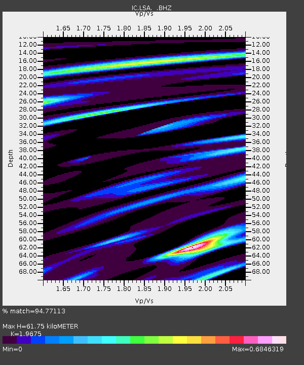
| Estimated Moho Depth: |
61.75 km |
| Estimated Crust Vp/Vs: |
1.97 |
| Assumed Crust Vp: |
6.514 km/s |
| Estimated Crust Vs: |
3.311 km/s |
| Estimated Crust Poisson's Ratio: |
0.33 |
|
| Radial Match: |
94.77113 % |
| Radial Bump: |
400 |
| Transverse Match: |
90.36195 % |
| Transverse Bump: |
400 |
| SOD ConfigId: |
4480 |
| Insert Time: |
2010-03-04 22:44:29.518 +0000 |
| GWidth: |
2.5 |
| Max Bumps: |
400 |
| Tol: |
0.001 |
|
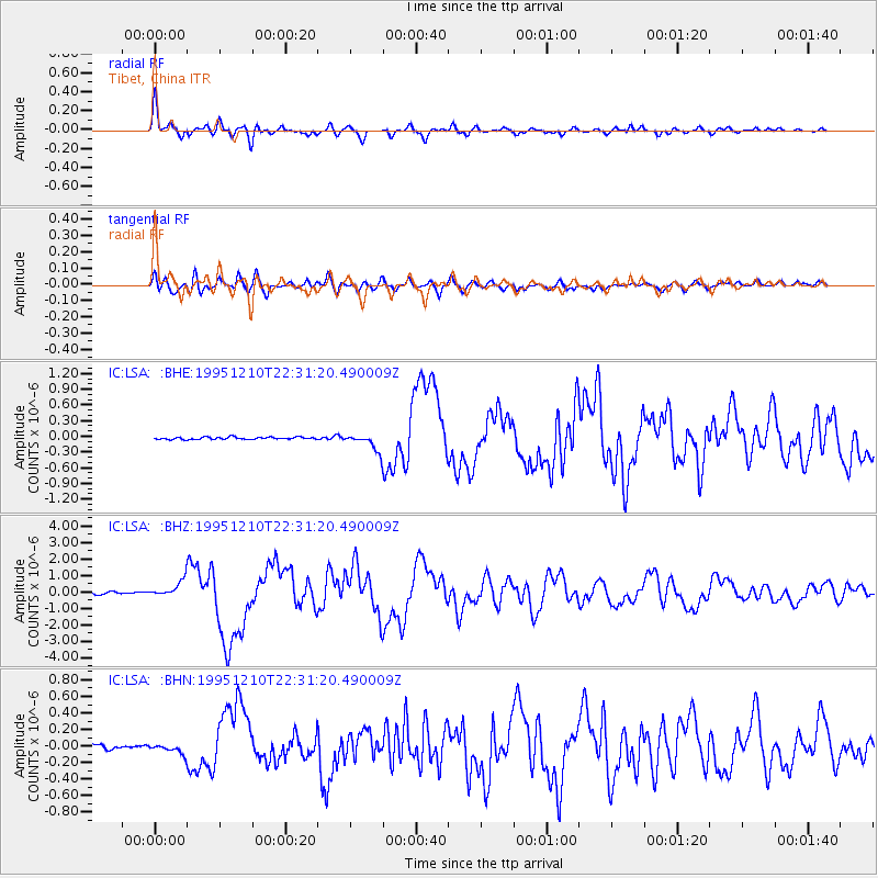
Signal To Noise
| Channel | StoN | STA | LTA |
| IC:LSA: :BHZ:19951210T22:31:20.490009Z | 5.944372 | 5.030008E-7 | 8.4617994E-8 |
| IC:LSA: :BHN:19951210T22:31:20.490009Z | 2.127429 | 5.8331523E-8 | 2.7418787E-8 |
| IC:LSA: :BHE:19951210T22:31:20.490009Z | 6.624785 | 1.4332939E-7 | 2.1635328E-8 |
| Arrivals |
| Ps | 9.7 SECOND |
| PpPs | 27 SECOND |
| PsPs/PpSs | 36 SECOND |


