You are here: Home > Network List > CI - Caltech Regional Seismic Network Stations List
> Station MPP McPhearson Peak > Earthquake Result Viewer
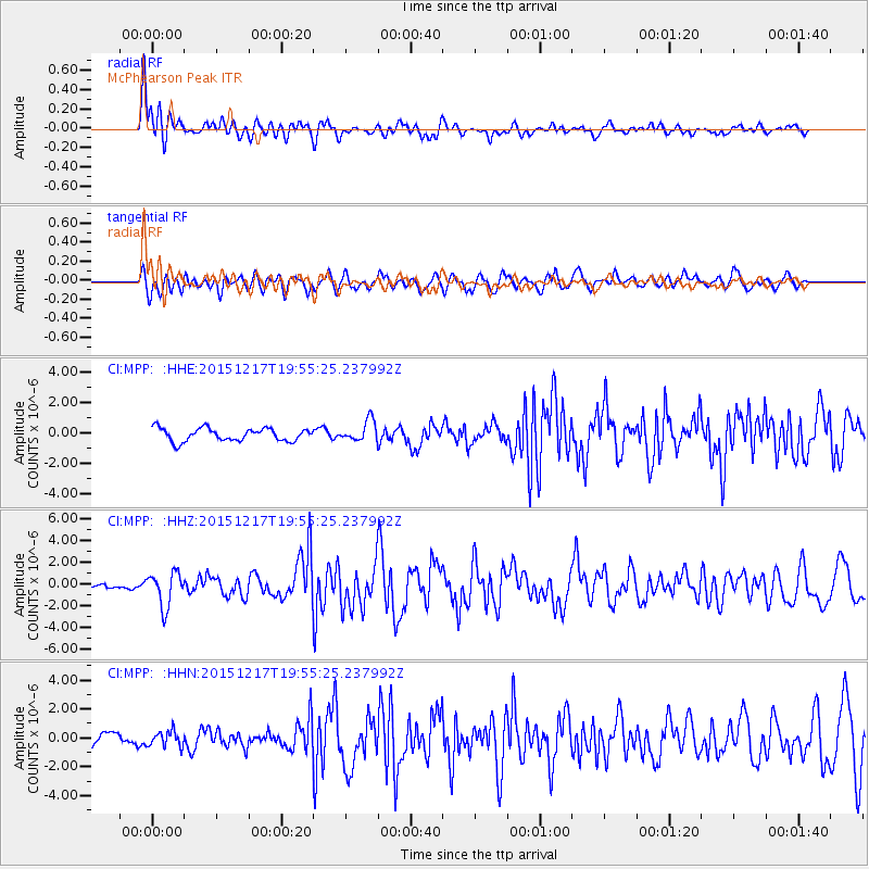
MPP McPhearson Peak - Earthquake Result Viewer
*The percent match for this event was below the threshold and hence no stack was calculated.
| Earthquake location: |
Near Coast Of Chiapas, Mexico |
| Earthquake latitude/longitude: |
15.9/-93.4 |
| Earthquake time(UTC): |
2015/12/17 (351) 19:49:54 GMT |
| Earthquake Depth: |
97 km |
| Earthquake Magnitude: |
6.4 MWB, 6.6 MI |
| Earthquake Catalog/Contributor: |
NEIC PDE/NEIC COMCAT |
|
| Network: |
CI Caltech Regional Seismic Network |
| Station: |
MPP McPhearson Peak |
| Lat/Lon: |
34.89 N/119.81 W |
| Elevation: |
1739 m |
|
| Distance: |
30.3 deg |
| Az: |
313.569 deg |
| Baz: |
121.993 deg |
| Ray Param: |
$rayparam |
*The percent match for this event was below the threshold and hence was not used in the summary stack. |
|
| Radial Match: |
81.35224 % |
| Radial Bump: |
400 |
| Transverse Match: |
62.946697 % |
| Transverse Bump: |
400 |
| SOD ConfigId: |
7422571 |
| Insert Time: |
2019-04-21 14:37:48.204 +0000 |
| GWidth: |
2.5 |
| Max Bumps: |
400 |
| Tol: |
0.001 |
|
Signal To Noise
| Channel | StoN | STA | LTA |
| CI:MPP: :HHZ:20151217T19:55:25.237992Z | 4.5837407 | 1.5732236E-6 | 3.432183E-7 |
| CI:MPP: :HHN:20151217T19:55:25.237992Z | 1.0642885 | 5.284848E-7 | 4.965616E-7 |
| CI:MPP: :HHE:20151217T19:55:25.237992Z | 1.8446896 | 7.4399276E-7 | 4.0331597E-7 |
| Arrivals |
| Ps | |
| PpPs | |
| PsPs/PpSs | |


