You are here: Home > Network List > CI - Caltech Regional Seismic Network Stations List
> Station VES Vestal, Richgrove, CA, USA > Earthquake Result Viewer
VES Vestal, Richgrove, CA, USA - Earthquake Result Viewer
| Earthquake location: |
Santa Cruz Islands |
| Earthquake latitude/longitude: |
-11.4/166.3 |
| Earthquake time(UTC): |
2007/08/12 (224) 12:05:19 GMT |
| Earthquake Depth: |
42 km |
| Earthquake Magnitude: |
5.8 MB, 5.7 MS, 6.0 MW, 6.0 MW |
| Earthquake Catalog/Contributor: |
WHDF/NEIC |
|
| Network: |
CI Caltech Regional Seismic Network |
| Station: |
VES Vestal, Richgrove, CA, USA |
| Lat/Lon: |
35.84 N/119.08 W |
| Elevation: |
154 m |
|
| Distance: |
84.4 deg |
| Az: |
51.923 deg |
| Baz: |
251.813 deg |
| Ray Param: |
0.045409996 |
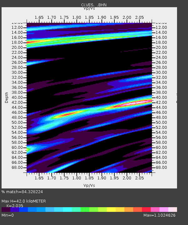
| Estimated Moho Depth: |
42.0 km |
| Estimated Crust Vp/Vs: |
2.04 |
| Assumed Crust Vp: |
6.1 km/s |
| Estimated Crust Vs: |
2.998 km/s |
| Estimated Crust Poisson's Ratio: |
0.34 |
|
| Radial Match: |
84.328224 % |
| Radial Bump: |
400 |
| Transverse Match: |
77.62027 % |
| Transverse Bump: |
332 |
| SOD ConfigId: |
2564 |
| Insert Time: |
2010-02-26 00:01:05.798 +0000 |
| GWidth: |
2.5 |
| Max Bumps: |
400 |
| Tol: |
0.001 |
|

Signal To Noise
| Channel | StoN | STA | LTA |
| CI:VES: :BHN:20070812T12:17:16.909021Z | 1.05367 | 1.9326717E-7 | 1.8342287E-7 |
| CI:VES: :BHE:20070812T12:17:16.909021Z | 2.422902 | 3.9598925E-7 | 1.6343591E-7 |
| CI:VES: :BHZ:20070812T12:17:16.909021Z | 7.241643 | 7.2143104E-7 | 9.962256E-8 |
| Arrivals |
| Ps | 7.3 SECOND |
| PpPs | 20 SECOND |
| PsPs/PpSs | 28 SECOND |


