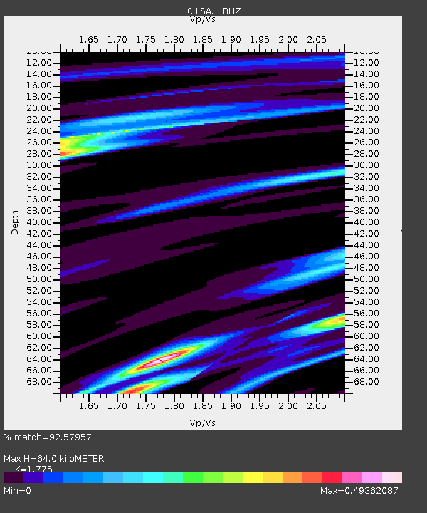
LSA Tibet, China - Earthquake Result Viewer
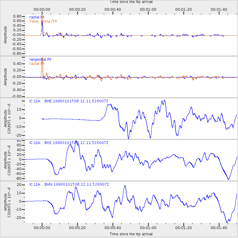
Earthquake location: Minahassa Peninsula, Sulawesi
Earthquake latitude/longitude: 0.7/120.0
Earthquake time(UTC): 1996/01/01 (001) 08:05:11 GMT
Earthquake Depth: 33 km
Earthquake Magnitude: 6.2 MB, 7.7 MS, 7.8 UNKNOWN, 7.8 MW
Earthquake Catalog/Contributor: WHDF/NEIC
Network: IC New China Digital Seismograph Network
Station: LSA Tibet, China
Lat/Lon: 29.70 N/91.15 E
Elevation: 3789 m
Distance: 39.8 deg
Az: 319.04 deg
Baz: 131.117 deg
Ray Param: 0.07470948
Estimated Moho Depth: 64.0 km
Estimated Crust Vp/Vs: 1.77
Assumed Crust Vp: 6.514 km/s
Estimated Crust Vs: 3.67 km/s
Estimated Crust Poisson's Ratio: 0.27
Radial Match: 92.57957 %
Radial Bump: 386
Transverse Match: 77.922905 %
Transverse Bump: 400
SOD ConfigId: 4480
Insert Time: 2010-03-04 22:44:50.746 +0000
GWidth: 2.5
Max Bumps: 400
Tol: 0.001

Signal To Noise

ChannelStoNSTALTA
IC:LSA: :BHZ:19960101T08:12:11.526007Z5.3876343.8128546E-67.077049E-7
IC:LSA: :BHN:19960101T08:12:11.526007Z4.08935831.0665582E-62.608131E-7
IC:LSA: :BHE:19960101T08:12:11.526007Z3.91734771.3574435E-63.4652103E-7
Arrivals
Ps8.2 SECOND
PpPs25 SECOND
PsPs/PpSs34 SECOND