You are here: Home > Network List > IC - New China Digital Seismograph Network Stations List
> Station LSA Tibet, China > Earthquake Result Viewer
LSA Tibet, China - Earthquake Result Viewer
| Earthquake location: |
Southern Molucca Sea |
| Earthquake latitude/longitude: |
-0.1/124.7 |
| Earthquake time(UTC): |
2005/12/21 (355) 07:09:05 GMT |
| Earthquake Depth: |
25 km |
| Earthquake Magnitude: |
6.3 MB, 5.9 MS, 6.3 MW, 6.2 MW |
| Earthquake Catalog/Contributor: |
WHDF/NEIC |
|
| Network: |
IC New China Digital Seismograph Network |
| Station: |
LSA Tibet, China |
| Lat/Lon: |
29.70 N/91.15 E |
| Elevation: |
3789 m |
|
| Distance: |
43.5 deg |
| Az: |
315.781 deg |
| Baz: |
126.721 deg |
| Ray Param: |
0.07243766 |
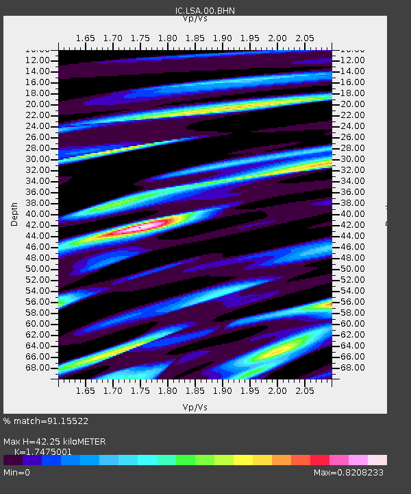
| Estimated Moho Depth: |
42.25 km |
| Estimated Crust Vp/Vs: |
1.75 |
| Assumed Crust Vp: |
6.514 km/s |
| Estimated Crust Vs: |
3.728 km/s |
| Estimated Crust Poisson's Ratio: |
0.26 |
|
| Radial Match: |
91.15522 % |
| Radial Bump: |
395 |
| Transverse Match: |
87.49603 % |
| Transverse Bump: |
400 |
| SOD ConfigId: |
2422 |
| Insert Time: |
2010-03-04 22:45:04.362 +0000 |
| GWidth: |
2.5 |
| Max Bumps: |
400 |
| Tol: |
0.001 |
|
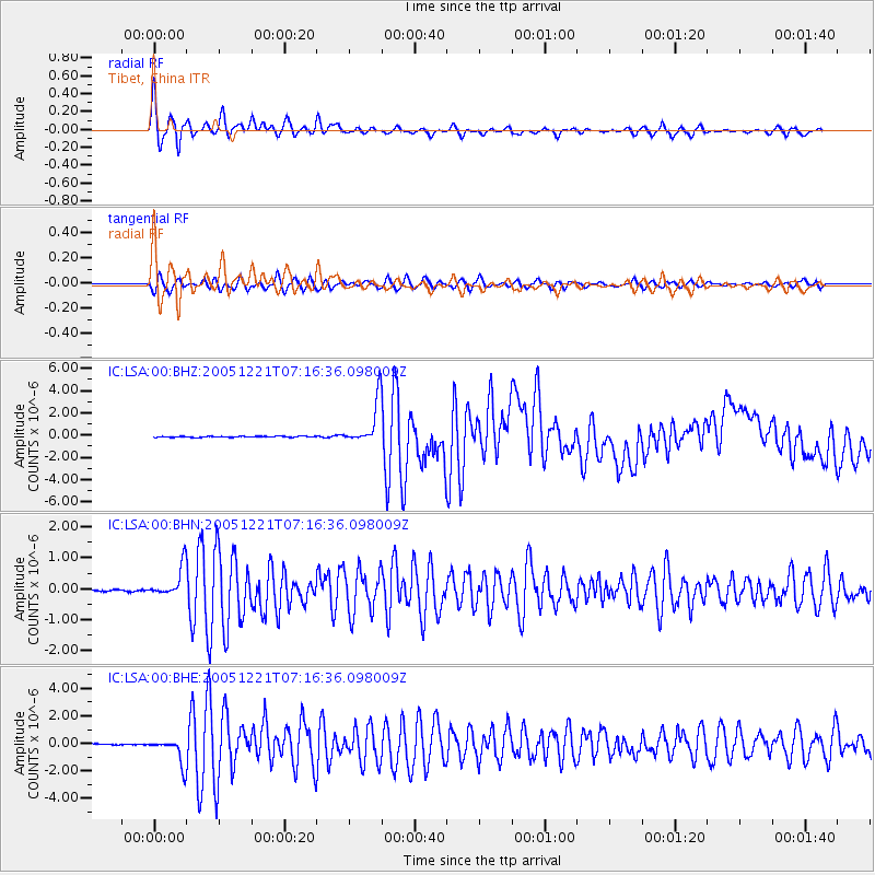
Signal To Noise
| Channel | StoN | STA | LTA |
| IC:LSA:00:BHN:20051221T07:16:36.098009Z | 19.208612 | 4.8834056E-7 | 2.5423E-8 |
| IC:LSA:00:BHE:20051221T07:16:36.098009Z | 20.465853 | 9.350547E-7 | 4.5688527E-8 |
| IC:LSA:00:BHZ:20051221T07:16:36.098009Z | 40.808758 | 1.9437184E-6 | 4.7629936E-8 |
| Arrivals |
| Ps | 5.2 SECOND |
| PpPs | 17 SECOND |
| PsPs/PpSs | 22 SECOND |


