You are here: Home > Network List > IC - New China Digital Seismograph Network Stations List
> Station LSA Tibet, China > Earthquake Result Viewer
LSA Tibet, China - Earthquake Result Viewer
| Earthquake location: |
Mindanao, Philippines |
| Earthquake latitude/longitude: |
6.3/124.0 |
| Earthquake time(UTC): |
2005/11/30 (334) 16:53:42 GMT |
| Earthquake Depth: |
13 km |
| Earthquake Magnitude: |
5.8 MB, 5.9 MS, 6.3 MW, 6.2 MW |
| Earthquake Catalog/Contributor: |
WHDF/NEIC |
|
| Network: |
IC New China Digital Seismograph Network |
| Station: |
LSA Tibet, China |
| Lat/Lon: |
29.70 N/91.15 E |
| Elevation: |
3789 m |
|
| Distance: |
38.8 deg |
| Az: |
311.012 deg |
| Baz: |
120.442 deg |
| Ray Param: |
0.07537269 |
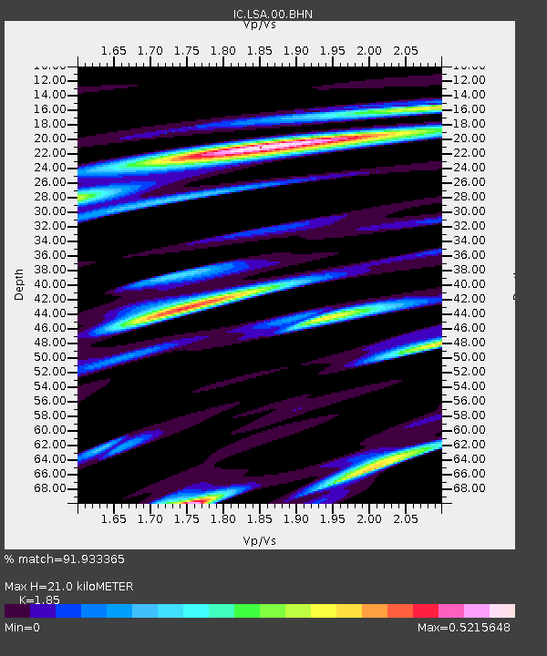
| Estimated Moho Depth: |
21.0 km |
| Estimated Crust Vp/Vs: |
1.85 |
| Assumed Crust Vp: |
6.514 km/s |
| Estimated Crust Vs: |
3.521 km/s |
| Estimated Crust Poisson's Ratio: |
0.29 |
|
| Radial Match: |
91.933365 % |
| Radial Bump: |
400 |
| Transverse Match: |
74.47516 % |
| Transverse Bump: |
400 |
| SOD ConfigId: |
2422 |
| Insert Time: |
2010-03-04 22:45:13.186 +0000 |
| GWidth: |
2.5 |
| Max Bumps: |
400 |
| Tol: |
0.001 |
|
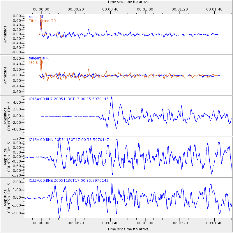
Signal To Noise
| Channel | StoN | STA | LTA |
| IC:LSA:00:BHN:20051130T17:00:35.597014Z | 2.5758328 | 6.621474E-8 | 2.5706145E-8 |
| IC:LSA:00:BHE:20051130T17:00:35.597014Z | 3.4179754 | 1.538255E-7 | 4.5004857E-8 |
| IC:LSA:00:BHZ:20051130T17:00:35.597014Z | 4.9382825 | 3.2632502E-7 | 6.608067E-8 |
| Arrivals |
| Ps | 2.9 SECOND |
| PpPs | 8.6 SECOND |
| PsPs/PpSs | 11 SECOND |


