You are here: Home > Network List > LD - Lamont-Doherty Cooperative Seismographic Network Stations List
> Station BRNY Black Rock Forest, Cornwall, NY > Earthquake Result Viewer
BRNY Black Rock Forest, Cornwall, NY - Earthquake Result Viewer
| Earthquake location: |
Near Coast Of Chiapas, Mexico |
| Earthquake latitude/longitude: |
15.9/-93.4 |
| Earthquake time(UTC): |
2015/12/17 (351) 19:49:54 GMT |
| Earthquake Depth: |
97 km |
| Earthquake Magnitude: |
6.4 MWB, 6.6 MI |
| Earthquake Catalog/Contributor: |
NEIC PDE/NEIC COMCAT |
|
| Network: |
LD Lamont-Doherty Cooperative Seismographic Network |
| Station: |
BRNY Black Rock Forest, Cornwall, NY |
| Lat/Lon: |
41.41 N/74.01 W |
| Elevation: |
248 m |
|
| Distance: |
30.5 deg |
| Az: |
29.548 deg |
| Baz: |
219.118 deg |
| Ray Param: |
0.079166554 |
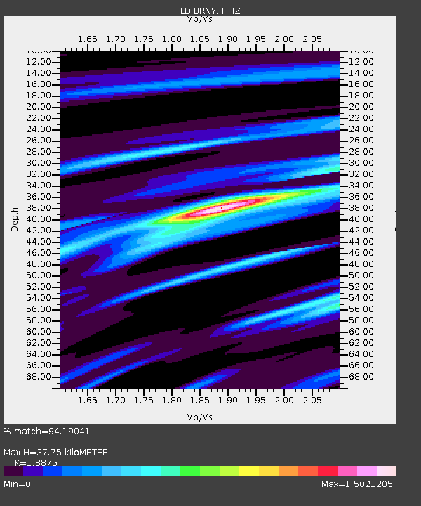
| Estimated Moho Depth: |
37.75 km |
| Estimated Crust Vp/Vs: |
1.89 |
| Assumed Crust Vp: |
6.283 km/s |
| Estimated Crust Vs: |
3.329 km/s |
| Estimated Crust Poisson's Ratio: |
0.30 |
|
| Radial Match: |
94.19041 % |
| Radial Bump: |
247 |
| Transverse Match: |
65.67154 % |
| Transverse Bump: |
400 |
| SOD ConfigId: |
7422571 |
| Insert Time: |
2019-04-21 14:39:50.711 +0000 |
| GWidth: |
2.5 |
| Max Bumps: |
400 |
| Tol: |
0.001 |
|

Signal To Noise
| Channel | StoN | STA | LTA |
| LD:BRNY: :HHZ:20151217T19:55:29.099991Z | 9.613969 | 2.8159845E-6 | 2.929055E-7 |
| LD:BRNY: :HHN:20151217T19:55:29.099991Z | 4.993403 | 1.5602317E-6 | 3.1245858E-7 |
| LD:BRNY: :HHE:20151217T19:55:29.099991Z | 7.1126847 | 1.658692E-6 | 2.3320196E-7 |
| Arrivals |
| Ps | 5.7 SECOND |
| PpPs | 16 SECOND |
| PsPs/PpSs | 22 SECOND |


