You are here: Home > Network List > LD - Lamont-Doherty Cooperative Seismographic Network Stations List
> Station HBVT Hinesburg, VT > Earthquake Result Viewer
HBVT Hinesburg, VT - Earthquake Result Viewer
| Earthquake location: |
Near Coast Of Chiapas, Mexico |
| Earthquake latitude/longitude: |
15.9/-93.4 |
| Earthquake time(UTC): |
2015/12/17 (351) 19:49:54 GMT |
| Earthquake Depth: |
97 km |
| Earthquake Magnitude: |
6.4 MWB, 6.6 MI |
| Earthquake Catalog/Contributor: |
NEIC PDE/NEIC COMCAT |
|
| Network: |
LD Lamont-Doherty Cooperative Seismographic Network |
| Station: |
HBVT Hinesburg, VT |
| Lat/Lon: |
44.36 N/73.07 W |
| Elevation: |
1130 m |
|
| Distance: |
33.2 deg |
| Az: |
27.112 deg |
| Baz: |
217.691 deg |
| Ray Param: |
0.07804255 |
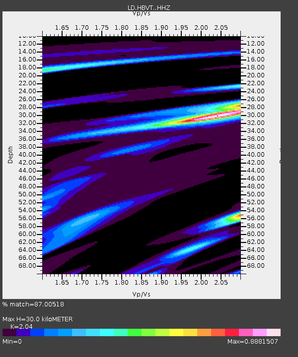
| Estimated Moho Depth: |
30.0 km |
| Estimated Crust Vp/Vs: |
2.04 |
| Assumed Crust Vp: |
6.419 km/s |
| Estimated Crust Vs: |
3.147 km/s |
| Estimated Crust Poisson's Ratio: |
0.34 |
|
| Radial Match: |
87.00518 % |
| Radial Bump: |
184 |
| Transverse Match: |
66.82569 % |
| Transverse Bump: |
400 |
| SOD ConfigId: |
7422571 |
| Insert Time: |
2019-04-21 14:39:55.521 +0000 |
| GWidth: |
2.5 |
| Max Bumps: |
400 |
| Tol: |
0.001 |
|

Signal To Noise
| Channel | StoN | STA | LTA |
| LD:HBVT: :HHZ:20151217T19:55:53.00499Z | 9.314646 | 2.8642373E-6 | 3.0749825E-7 |
| LD:HBVT: :HHN:20151217T19:55:53.00499Z | 7.2496953 | 1.6599324E-6 | 2.2896582E-7 |
| LD:HBVT: :HHE:20151217T19:55:53.00499Z | 4.973308 | 1.2638121E-6 | 2.5411902E-7 |
| Arrivals |
| Ps | 5.2 SECOND |
| PpPs | 13 SECOND |
| PsPs/PpSs | 18 SECOND |


