You are here: Home > Network List > LD - Lamont-Doherty Cooperative Seismographic Network Stations List
> Station PAL Palisades, New York > Earthquake Result Viewer
PAL Palisades, New York - Earthquake Result Viewer
| Earthquake location: |
Near Coast Of Chiapas, Mexico |
| Earthquake latitude/longitude: |
15.9/-93.4 |
| Earthquake time(UTC): |
2015/12/17 (351) 19:49:54 GMT |
| Earthquake Depth: |
97 km |
| Earthquake Magnitude: |
6.4 MWB, 6.6 MI |
| Earthquake Catalog/Contributor: |
NEIC PDE/NEIC COMCAT |
|
| Network: |
LD Lamont-Doherty Cooperative Seismographic Network |
| Station: |
PAL Palisades, New York |
| Lat/Lon: |
41.01 N/73.91 W |
| Elevation: |
66 m |
|
| Distance: |
30.2 deg |
| Az: |
30.182 deg |
| Baz: |
219.733 deg |
| Ray Param: |
0.07923606 |
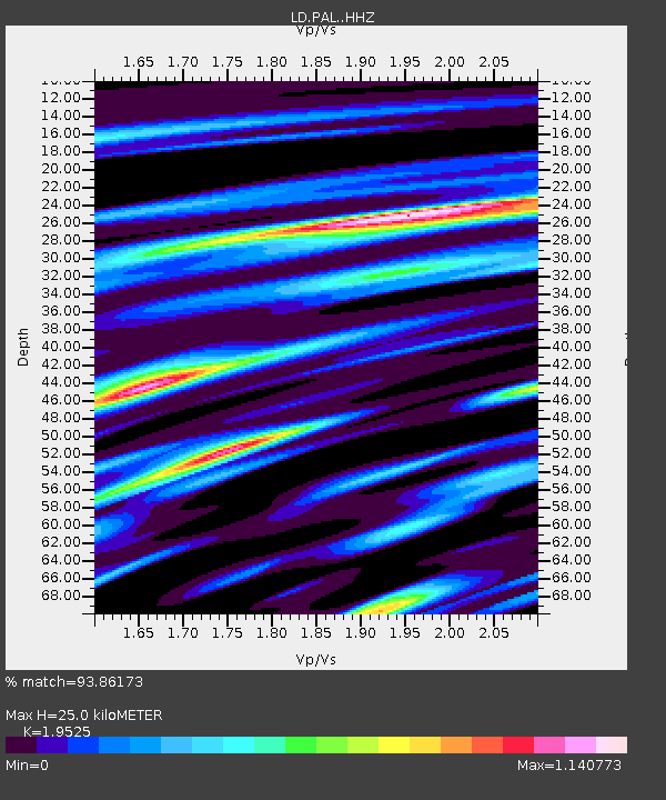
| Estimated Moho Depth: |
25.0 km |
| Estimated Crust Vp/Vs: |
1.95 |
| Assumed Crust Vp: |
6.472 km/s |
| Estimated Crust Vs: |
3.315 km/s |
| Estimated Crust Poisson's Ratio: |
0.32 |
|
| Radial Match: |
93.86173 % |
| Radial Bump: |
361 |
| Transverse Match: |
72.16357 % |
| Transverse Bump: |
400 |
| SOD ConfigId: |
7422571 |
| Insert Time: |
2019-04-21 14:40:01.623 +0000 |
| GWidth: |
2.5 |
| Max Bumps: |
400 |
| Tol: |
0.001 |
|

Signal To Noise
| Channel | StoN | STA | LTA |
| LD:PAL: :HHZ:20151217T19:55:26.778Z | 8.226612 | 3.0529602E-6 | 3.7110783E-7 |
| LD:PAL: :HHN:20151217T19:55:26.778Z | 4.615882 | 1.2428281E-6 | 2.6925042E-7 |
| LD:PAL: :HHE:20151217T19:55:26.778Z | 2.6863437 | 1.1791974E-6 | 4.3896E-7 |
| Arrivals |
| Ps | 4.0 SECOND |
| PpPs | 11 SECOND |
| PsPs/PpSs | 15 SECOND |


