You are here: Home > Network List > MQ - Martinique Seismic and Volcano Observatory Network Stations List
> Station ZAM Zone Aero-Militaire - Martinique > Earthquake Result Viewer
ZAM Zone Aero-Militaire - Martinique - Earthquake Result Viewer
| Earthquake location: |
Near Coast Of Chiapas, Mexico |
| Earthquake latitude/longitude: |
15.9/-93.4 |
| Earthquake time(UTC): |
2015/12/17 (351) 19:49:54 GMT |
| Earthquake Depth: |
97 km |
| Earthquake Magnitude: |
6.4 MWB, 6.6 MI |
| Earthquake Catalog/Contributor: |
NEIC PDE/NEIC COMCAT |
|
| Network: |
MQ Martinique Seismic and Volcano Observatory Network |
| Station: |
ZAM Zone Aero-Militaire - Martinique |
| Lat/Lon: |
14.59 N/61.02 W |
| Elevation: |
11 m |
|
| Distance: |
31.3 deg |
| Az: |
87.974 deg |
| Baz: |
276.655 deg |
| Ray Param: |
0.07889042 |
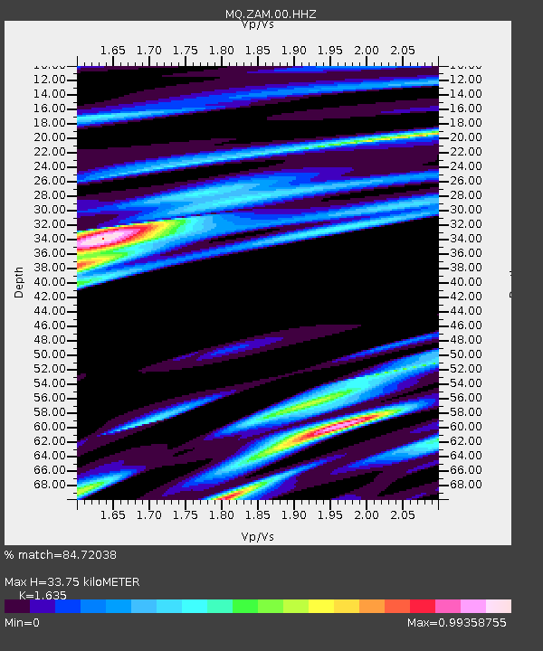
| Estimated Moho Depth: |
33.75 km |
| Estimated Crust Vp/Vs: |
1.63 |
| Assumed Crust Vp: |
5.88 km/s |
| Estimated Crust Vs: |
3.597 km/s |
| Estimated Crust Poisson's Ratio: |
0.20 |
|
| Radial Match: |
84.72038 % |
| Radial Bump: |
400 |
| Transverse Match: |
67.9041 % |
| Transverse Bump: |
400 |
| SOD ConfigId: |
7422571 |
| Insert Time: |
2019-04-21 14:40:20.456 +0000 |
| GWidth: |
2.5 |
| Max Bumps: |
400 |
| Tol: |
0.001 |
|

Signal To Noise
| Channel | StoN | STA | LTA |
| MQ:ZAM:00:HHZ:20151217T19:55:36.409989Z | 15.318975 | 3.9757374E-6 | 2.5953022E-7 |
| MQ:ZAM:00:HHN:20151217T19:55:36.409989Z | 5.081812 | 1.3374703E-6 | 2.6318767E-7 |
| MQ:ZAM:00:HHE:20151217T19:55:36.409989Z | 7.360939 | 2.2601266E-6 | 3.0704322E-7 |
| Arrivals |
| Ps | 3.9 SECOND |
| PpPs | 14 SECOND |
| PsPs/PpSs | 18 SECOND |


