You are here: Home > Network List > N4 - Central and EAstern US Network Stations List
> Station D32B Dogwood Acres, Gardner, ND, USA > Earthquake Result Viewer
D32B Dogwood Acres, Gardner, ND, USA - Earthquake Result Viewer
| Earthquake location: |
Near Coast Of Chiapas, Mexico |
| Earthquake latitude/longitude: |
15.9/-93.4 |
| Earthquake time(UTC): |
2015/12/17 (351) 19:49:54 GMT |
| Earthquake Depth: |
97 km |
| Earthquake Magnitude: |
6.4 MWB, 6.6 MI |
| Earthquake Catalog/Contributor: |
NEIC PDE/NEIC COMCAT |
|
| Network: |
N4 Central and EAstern US Network |
| Station: |
D32B Dogwood Acres, Gardner, ND, USA |
| Lat/Lon: |
47.14 N/97.02 W |
| Elevation: |
271 m |
|
| Distance: |
31.3 deg |
| Az: |
355.283 deg |
| Baz: |
173.344 deg |
| Ray Param: |
0.07888334 |
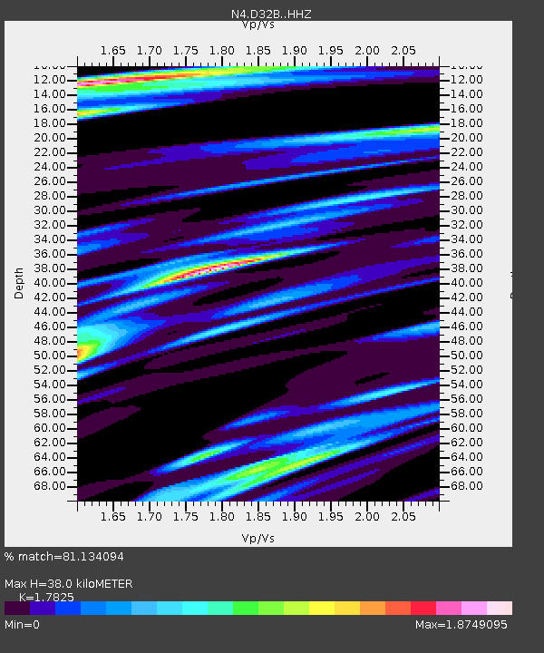
| Estimated Moho Depth: |
38.0 km |
| Estimated Crust Vp/Vs: |
1.78 |
| Assumed Crust Vp: |
6.498 km/s |
| Estimated Crust Vs: |
3.645 km/s |
| Estimated Crust Poisson's Ratio: |
0.27 |
|
| Radial Match: |
81.134094 % |
| Radial Bump: |
400 |
| Transverse Match: |
36.534687 % |
| Transverse Bump: |
400 |
| SOD ConfigId: |
7422571 |
| Insert Time: |
2019-04-21 14:40:22.961 +0000 |
| GWidth: |
2.5 |
| Max Bumps: |
400 |
| Tol: |
0.001 |
|

Signal To Noise
| Channel | StoN | STA | LTA |
| N4:D32B: :HHZ:20151217T19:55:35.499985Z | 10.311462 | 4.3355176E-6 | 4.2045616E-7 |
| N4:D32B: :HHN:20151217T19:55:35.499985Z | 13.75355 | 6.2112094E-6 | 4.5160772E-7 |
| N4:D32B: :HHE:20151217T19:55:35.499985Z | 4.564898 | 2.189446E-6 | 4.7962646E-7 |
| Arrivals |
| Ps | 5.0 SECOND |
| PpPs | 15 SECOND |
| PsPs/PpSs | 20 SECOND |


