You are here: Home > Network List > N4 - Central and EAstern US Network Stations List
> Station E38A The Farm, Brule, WI, USA > Earthquake Result Viewer
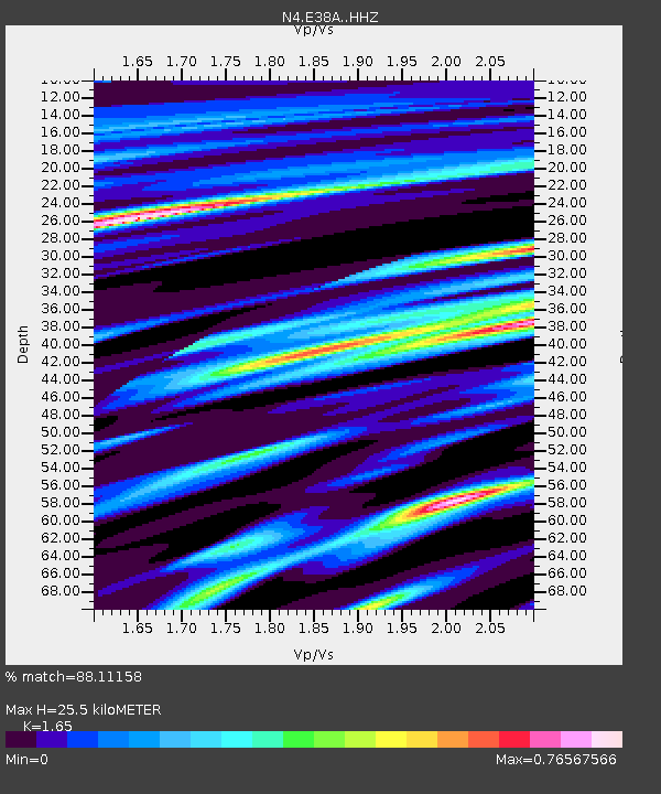
E38A The Farm, Brule, WI, USA - Earthquake Result Viewer
| Earthquake location: |
Near Coast Of Chiapas, Mexico |
| Earthquake latitude/longitude: |
15.9/-93.4 |
| Earthquake time(UTC): |
2015/12/17 (351) 19:49:54 GMT |
| Earthquake Depth: |
97 km |
| Earthquake Magnitude: |
6.4 MWB, 6.6 MI |
| Earthquake Catalog/Contributor: |
NEIC PDE/NEIC COMCAT |
|
| Network: |
N4 Central and EAstern US Network |
| Station: |
E38A The Farm, Brule, WI, USA |
| Lat/Lon: |
46.61 N/91.55 W |
| Elevation: |
341 m |
|
| Distance: |
30.7 deg |
| Az: |
2.535 deg |
| Baz: |
183.54 deg |
| Ray Param: |
0.07911515 |
| Estimated Moho Depth: |
25.5 km |
| Estimated Crust Vp/Vs: |
1.65 |
| Assumed Crust Vp: |
6.467 km/s |
| Estimated Crust Vs: |
3.919 km/s |
| Estimated Crust Poisson's Ratio: |
0.21 |
|
| Radial Match: |
88.11158 % |
| Radial Bump: |
400 |
| Transverse Match: |
58.567375 % |
| Transverse Bump: |
400 |
| SOD ConfigId: |
7422571 |
| Insert Time: |
2019-04-21 14:40:25.549 +0000 |
| GWidth: |
2.5 |
| Max Bumps: |
400 |
| Tol: |
0.001 |
|

Signal To Noise
| Channel | StoN | STA | LTA |
| N4:E38A: :HHZ:20151217T19:55:30.169999Z | 10.37416 | 5.7756147E-6 | 5.5673087E-7 |
| N4:E38A: :HHN:20151217T19:55:30.169999Z | 5.0836897 | 2.8950324E-6 | 5.6947465E-7 |
| N4:E38A: :HHE:20151217T19:55:30.169999Z | 1.7460709 | 6.6451884E-7 | 3.8057954E-7 |
| Arrivals |
| Ps | 2.8 SECOND |
| PpPs | 9.6 SECOND |
| PsPs/PpSs | 12 SECOND |


