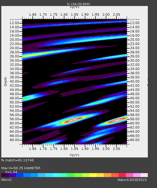
LSA Tibet, China - Earthquake Result Viewer
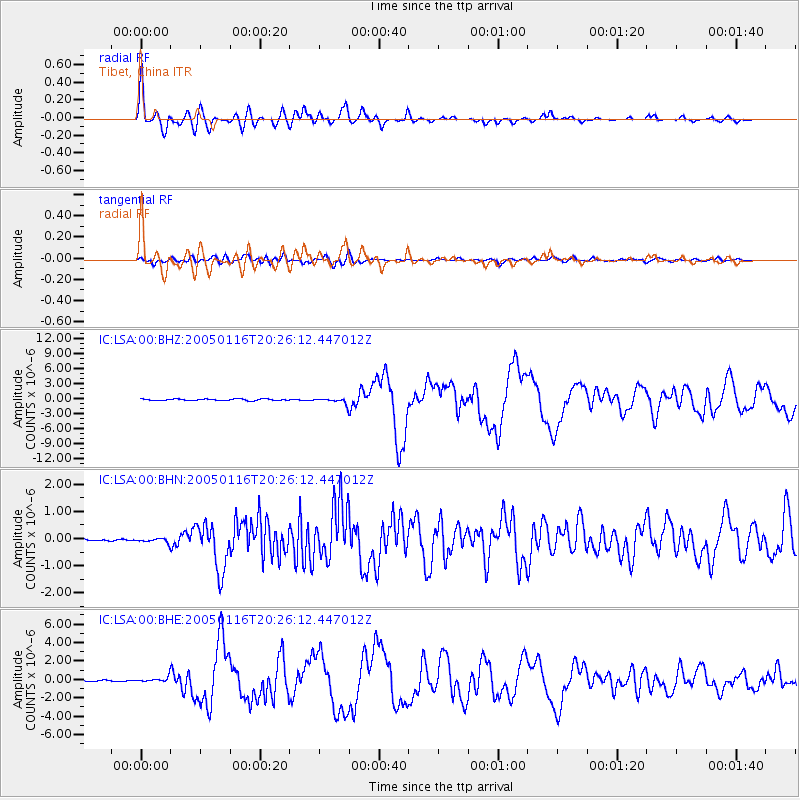
Earthquake location: W. Caroline Islands, Micronesia
Earthquake latitude/longitude: 10.9/140.8
Earthquake time(UTC): 2005/01/16 (016) 20:17:52 GMT
Earthquake Depth: 25 km
Earthquake Magnitude: 6.3 MB, 6.7 MS, 6.6 MW, 6.6 MW
Earthquake Catalog/Contributor: WHDF/NEIC
Network: IC New China Digital Seismograph Network
Station: LSA Tibet, China
Lat/Lon: 29.70 N/91.15 E
Elevation: 3789 m
Distance: 49.8 deg
Az: 299.674 deg
Baz: 101.268 deg
Ray Param: 0.06844057
Estimated Moho Depth: 58.25 km
Estimated Crust Vp/Vs: 1.84
Assumed Crust Vp: 6.514 km/s
Estimated Crust Vs: 3.54 km/s
Estimated Crust Poisson's Ratio: 0.29
Radial Match: 91.10748 %
Radial Bump: 400
Transverse Match: 76.47839 %
Transverse Bump: 400
SOD ConfigId: 5233
Insert Time: 2010-03-04 22:45:43.057 +0000
GWidth: 2.5
Max Bumps: 400
Tol: 0.001

Signal To Noise

ChannelStoNSTALTA
IC:LSA:00:BHN:20050116T20:26:12.447012Z2.03981977.483935E-83.6689197E-8
IC:LSA:00:BHE:20050116T20:26:12.447012Z4.2070772.5444552E-76.048036E-8
IC:LSA:00:BHZ:20050116T20:26:12.447012Z3.52209545.4513515E-71.547758E-7
Arrivals
Ps8.0 SECOND
PpPs24 SECOND
PsPs/PpSs32 SECOND