You are here: Home > Network List > NI - North-East Italy Broadband Network Stations List
> Station DRE Drenchia > Earthquake Result Viewer
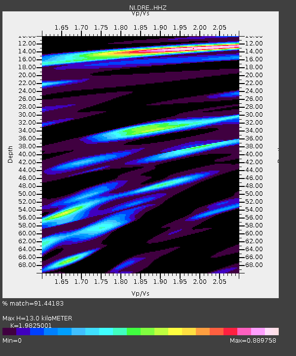
DRE Drenchia - Earthquake Result Viewer
| Earthquake location: |
Near Coast Of Chiapas, Mexico |
| Earthquake latitude/longitude: |
15.9/-93.4 |
| Earthquake time(UTC): |
2015/12/17 (351) 19:49:54 GMT |
| Earthquake Depth: |
97 km |
| Earthquake Magnitude: |
6.4 MWB, 6.6 MI |
| Earthquake Catalog/Contributor: |
NEIC PDE/NEIC COMCAT |
|
| Network: |
NI North-East Italy Broadband Network |
| Station: |
DRE Drenchia |
| Lat/Lon: |
46.17 N/13.65 E |
| Elevation: |
810 m |
|
| Distance: |
90.0 deg |
| Az: |
41.626 deg |
| Baz: |
293.096 deg |
| Ray Param: |
0.041683197 |
| Estimated Moho Depth: |
13.0 km |
| Estimated Crust Vp/Vs: |
1.98 |
| Assumed Crust Vp: |
6.35 km/s |
| Estimated Crust Vs: |
3.203 km/s |
| Estimated Crust Poisson's Ratio: |
0.33 |
|
| Radial Match: |
91.44183 % |
| Radial Bump: |
373 |
| Transverse Match: |
84.85996 % |
| Transverse Bump: |
400 |
| SOD ConfigId: |
7422571 |
| Insert Time: |
2019-04-21 14:40:50.891 +0000 |
| GWidth: |
2.5 |
| Max Bumps: |
400 |
| Tol: |
0.001 |
|

Signal To Noise
| Channel | StoN | STA | LTA |
| NI:DRE: :HHZ:20151217T20:02:12.937974Z | 29.406559 | 3.5817932E-6 | 1.2180251E-7 |
| NI:DRE: :HHN:20151217T20:02:12.937974Z | 8.406056 | 6.971439E-7 | 8.293352E-8 |
| NI:DRE: :HHE:20151217T20:02:12.937974Z | 5.2163258 | 8.762602E-7 | 1.6798417E-7 |
| Arrivals |
| Ps | 2.0 SECOND |
| PpPs | 6.0 SECOND |
| PsPs/PpSs | 8.0 SECOND |


