You are here: Home > Network List > PM - Portuguese National Seismic Network Stations List
> Station PVAQ PM.PVAQ > Earthquake Result Viewer
PVAQ PM.PVAQ - Earthquake Result Viewer
| Earthquake location: |
Near Coast Of Chiapas, Mexico |
| Earthquake latitude/longitude: |
15.9/-93.4 |
| Earthquake time(UTC): |
2015/12/17 (351) 19:49:54 GMT |
| Earthquake Depth: |
97 km |
| Earthquake Magnitude: |
6.4 MWB, 6.6 MI |
| Earthquake Catalog/Contributor: |
NEIC PDE/NEIC COMCAT |
|
| Network: |
PM Portuguese National Seismic Network |
| Station: |
PVAQ PM.PVAQ |
| Lat/Lon: |
37.40 N/7.72 W |
| Elevation: |
200 m |
|
| Distance: |
77.2 deg |
| Az: |
54.529 deg |
| Baz: |
280.231 deg |
| Ray Param: |
0.050276037 |
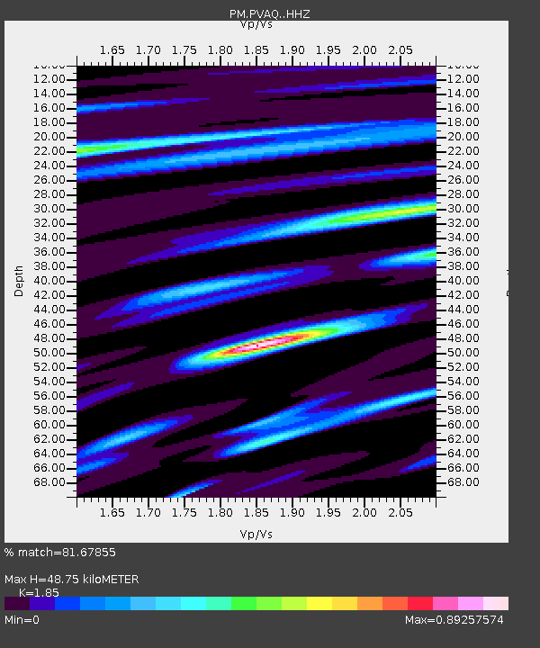
| Estimated Moho Depth: |
48.75 km |
| Estimated Crust Vp/Vs: |
1.85 |
| Assumed Crust Vp: |
6.391 km/s |
| Estimated Crust Vs: |
3.454 km/s |
| Estimated Crust Poisson's Ratio: |
0.29 |
|
| Radial Match: |
81.67855 % |
| Radial Bump: |
400 |
| Transverse Match: |
82.11217 % |
| Transverse Bump: |
400 |
| SOD ConfigId: |
7422571 |
| Insert Time: |
2019-04-21 14:41:30.210 +0000 |
| GWidth: |
2.5 |
| Max Bumps: |
400 |
| Tol: |
0.001 |
|

Signal To Noise
| Channel | StoN | STA | LTA |
| PM:PVAQ: :HHZ:20151217T20:01:07.790024Z | 6.3690915 | 1.9416375E-6 | 3.0485313E-7 |
| PM:PVAQ: :HHN:20151217T20:01:07.790024Z | 3.2182503 | 4.513775E-7 | 1.4025557E-7 |
| PM:PVAQ: :HHE:20151217T20:01:07.790024Z | 3.9450765 | 7.5811755E-7 | 1.9216802E-7 |
| Arrivals |
| Ps | 6.7 SECOND |
| PpPs | 21 SECOND |
| PsPs/PpSs | 28 SECOND |


