You are here: Home > Network List > PO - Portable Observatories for Lithospheric Analysis and Research Investigating Seis Stations List
> Station MATQ Matagami, QC > Earthquake Result Viewer
MATQ Matagami, QC - Earthquake Result Viewer
| Earthquake location: |
Near Coast Of Chiapas, Mexico |
| Earthquake latitude/longitude: |
15.9/-93.4 |
| Earthquake time(UTC): |
2015/12/17 (351) 19:49:54 GMT |
| Earthquake Depth: |
97 km |
| Earthquake Magnitude: |
6.4 MWB, 6.6 MI |
| Earthquake Catalog/Contributor: |
NEIC PDE/NEIC COMCAT |
|
| Network: |
PO Portable Observatories for Lithospheric Analysis and Research Investigating Seis |
| Station: |
MATQ Matagami, QC |
| Lat/Lon: |
49.76 N/77.64 W |
| Elevation: |
280 m |
|
| Distance: |
36.1 deg |
| Az: |
17.416 deg |
| Baz: |
206.365 deg |
| Ray Param: |
0.07653582 |
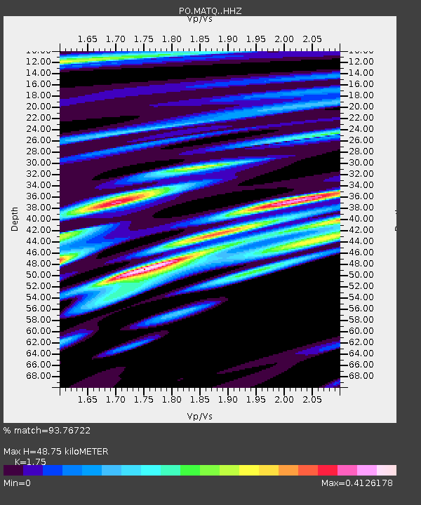
| Estimated Moho Depth: |
48.75 km |
| Estimated Crust Vp/Vs: |
1.75 |
| Assumed Crust Vp: |
6.61 km/s |
| Estimated Crust Vs: |
3.777 km/s |
| Estimated Crust Poisson's Ratio: |
0.26 |
|
| Radial Match: |
93.76722 % |
| Radial Bump: |
171 |
| Transverse Match: |
83.98869 % |
| Transverse Bump: |
395 |
| SOD ConfigId: |
7422571 |
| Insert Time: |
2019-04-21 14:41:38.903 +0000 |
| GWidth: |
2.5 |
| Max Bumps: |
400 |
| Tol: |
0.001 |
|

Signal To Noise
| Channel | StoN | STA | LTA |
| PO:MATQ: :HHZ:20151217T19:56:17.890Z | 10.8849535 | 3.6949014E-6 | 3.3945037E-7 |
| PO:MATQ: :HHN:20151217T19:56:17.890Z | 6.938721 | 1.7644682E-6 | 2.5429298E-7 |
| PO:MATQ: :HHE:20151217T19:56:17.890Z | 1.0821297 | 3.493638E-7 | 3.2284836E-7 |
| Arrivals |
| Ps | 6.0 SECOND |
| PpPs | 19 SECOND |
| PsPs/PpSs | 25 SECOND |


