You are here: Home > Network List > IC - New China Digital Seismograph Network Stations List
> Station LSA Tibet, China > Earthquake Result Viewer
LSA Tibet, China - Earthquake Result Viewer
| Earthquake location: |
Eastern Gulf Of Aden |
| Earthquake latitude/longitude: |
14.4/52.4 |
| Earthquake time(UTC): |
2005/08/26 (238) 18:16:33 GMT |
| Earthquake Depth: |
10 km |
| Earthquake Magnitude: |
5.7 MB, 5.9 MS, 6.2 MW, 6.2 MW |
| Earthquake Catalog/Contributor: |
WHDF/NEIC |
|
| Network: |
IC New China Digital Seismograph Network |
| Station: |
LSA Tibet, China |
| Lat/Lon: |
29.70 N/91.15 E |
| Elevation: |
3789 m |
|
| Distance: |
38.8 deg |
| Az: |
60.382 deg |
| Baz: |
255.493 deg |
| Ray Param: |
0.07533959 |
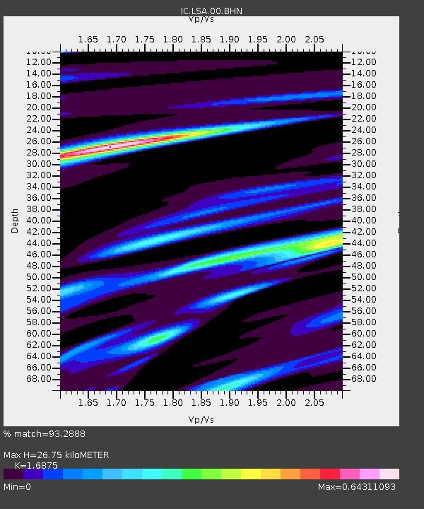
| Estimated Moho Depth: |
26.75 km |
| Estimated Crust Vp/Vs: |
1.69 |
| Assumed Crust Vp: |
6.514 km/s |
| Estimated Crust Vs: |
3.86 km/s |
| Estimated Crust Poisson's Ratio: |
0.23 |
|
| Radial Match: |
93.2888 % |
| Radial Bump: |
240 |
| Transverse Match: |
73.30009 % |
| Transverse Bump: |
400 |
| SOD ConfigId: |
2669 |
| Insert Time: |
2010-03-04 22:45:56.029 +0000 |
| GWidth: |
2.5 |
| Max Bumps: |
400 |
| Tol: |
0.001 |
|

Signal To Noise
| Channel | StoN | STA | LTA |
| IC:LSA:00:BHN:20050826T18:23:27.798009Z | 0.553182 | 1.3182109E-8 | 2.3829605E-8 |
| IC:LSA:00:BHE:20050826T18:23:27.798009Z | 1.1325939 | 4.9034245E-8 | 4.329376E-8 |
| IC:LSA:00:BHZ:20050826T18:23:27.798009Z | 1.0243322 | 7.955392E-8 | 7.766418E-8 |
| Arrivals |
| Ps | 3.1 SECOND |
| PpPs | 10 SECOND |
| PsPs/PpSs | 13 SECOND |


