You are here: Home > Network List > TA - USArray Transportable Network (new EarthScope stations) Stations List
> Station L20K Farewell, AK, USA > Earthquake Result Viewer
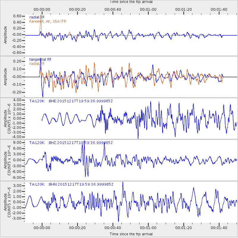
L20K Farewell, AK, USA - Earthquake Result Viewer
*The percent match for this event was below the threshold and hence no stack was calculated.
| Earthquake location: |
Near Coast Of Chiapas, Mexico |
| Earthquake latitude/longitude: |
15.9/-93.4 |
| Earthquake time(UTC): |
2015/12/17 (351) 19:49:54 GMT |
| Earthquake Depth: |
97 km |
| Earthquake Magnitude: |
6.4 MWB, 6.6 MI |
| Earthquake Catalog/Contributor: |
NEIC PDE/NEIC COMCAT |
|
| Network: |
TA USArray Transportable Network (new EarthScope stations) |
| Station: |
L20K Farewell, AK, USA |
| Lat/Lon: |
62.48 N/153.88 W |
| Elevation: |
673 m |
|
| Distance: |
62.5 deg |
| Az: |
332.903 deg |
| Baz: |
109.343 deg |
| Ray Param: |
$rayparam |
*The percent match for this event was below the threshold and hence was not used in the summary stack. |
|
| Radial Match: |
66.11587 % |
| Radial Bump: |
400 |
| Transverse Match: |
52.618103 % |
| Transverse Bump: |
400 |
| SOD ConfigId: |
7422571 |
| Insert Time: |
2019-04-21 14:42:28.206 +0000 |
| GWidth: |
2.5 |
| Max Bumps: |
400 |
| Tol: |
0.001 |
|
Signal To Noise
| Channel | StoN | STA | LTA |
| TA:L20K: :BHZ:20151217T19:59:36.999985Z | 4.1151605 | 2.8802058E-6 | 6.999012E-7 |
| TA:L20K: :BHN:20151217T19:59:36.999985Z | 1.1974374 | 6.8688325E-7 | 5.736277E-7 |
| TA:L20K: :BHE:20151217T19:59:36.999985Z | 1.6102908 | 1.1491319E-6 | 7.136176E-7 |
| Arrivals |
| Ps | |
| PpPs | |
| PsPs/PpSs | |


