You are here: Home > Network List > TD - TransAlta Monitoring Network Stations List
> Station TD004 Z > Earthquake Result Viewer
TD004 Z - Earthquake Result Viewer
| Earthquake location: |
Near Coast Of Chiapas, Mexico |
| Earthquake latitude/longitude: |
15.9/-93.4 |
| Earthquake time(UTC): |
2015/12/17 (351) 19:49:54 GMT |
| Earthquake Depth: |
97 km |
| Earthquake Magnitude: |
6.4 MWB, 6.6 MI |
| Earthquake Catalog/Contributor: |
NEIC PDE/NEIC COMCAT |
|
| Network: |
TD TransAlta Monitoring Network |
| Station: |
TD004 Z |
| Lat/Lon: |
53.47 N/114.63 W |
| Elevation: |
791 m |
|
| Distance: |
41.0 deg |
| Az: |
340.769 deg |
| Baz: |
147.985 deg |
| Ray Param: |
0.07371739 |
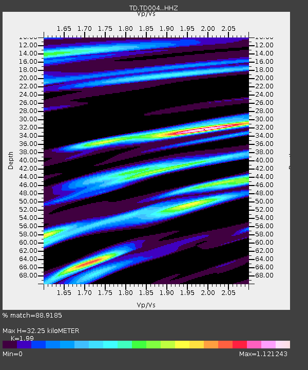
| Estimated Moho Depth: |
32.25 km |
| Estimated Crust Vp/Vs: |
1.99 |
| Assumed Crust Vp: |
6.426 km/s |
| Estimated Crust Vs: |
3.229 km/s |
| Estimated Crust Poisson's Ratio: |
0.33 |
|
| Radial Match: |
88.9185 % |
| Radial Bump: |
311 |
| Transverse Match: |
70.12263 % |
| Transverse Bump: |
373 |
| SOD ConfigId: |
7422571 |
| Insert Time: |
2019-04-21 14:42:44.288 +0000 |
| GWidth: |
2.5 |
| Max Bumps: |
400 |
| Tol: |
0.001 |
|

Signal To Noise
| Channel | StoN | STA | LTA |
| TD:TD004: :HHZ:20151217T19:56:57.65001Z | 13.311933 | 6.5901954E-6 | 4.950592E-7 |
| TD:TD004: :HH1:20151217T19:56:57.65001Z | 2.6483672 | 1.5230047E-6 | 5.750731E-7 |
| TD:TD004: :HH2:20151217T19:56:57.65001Z | 6.2716737 | 3.6366437E-6 | 5.7985216E-7 |
| Arrivals |
| Ps | 5.3 SECOND |
| PpPs | 14 SECOND |
| PsPs/PpSs | 19 SECOND |


