You are here: Home > Network List > TD - TransAlta Monitoring Network Stations List
> Station TD026 Z > Earthquake Result Viewer
TD026 Z - Earthquake Result Viewer
| Earthquake location: |
Near Coast Of Chiapas, Mexico |
| Earthquake latitude/longitude: |
15.9/-93.4 |
| Earthquake time(UTC): |
2015/12/17 (351) 19:49:54 GMT |
| Earthquake Depth: |
97 km |
| Earthquake Magnitude: |
6.4 MWB, 6.6 MI |
| Earthquake Catalog/Contributor: |
NEIC PDE/NEIC COMCAT |
|
| Network: |
TD TransAlta Monitoring Network |
| Station: |
TD026 Z |
| Lat/Lon: |
51.29 N/114.71 W |
| Elevation: |
1359 m |
|
| Distance: |
39.2 deg |
| Az: |
338.874 deg |
| Baz: |
146.472 deg |
| Ray Param: |
0.07479613 |
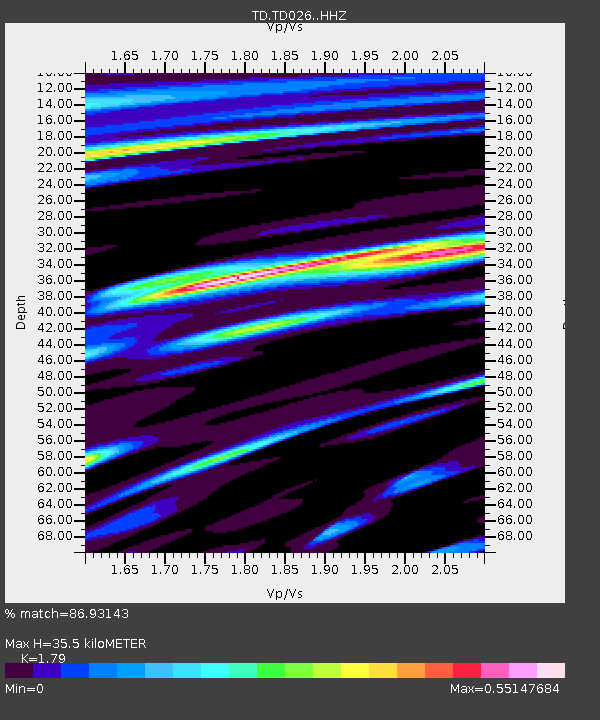
| Estimated Moho Depth: |
35.5 km |
| Estimated Crust Vp/Vs: |
1.79 |
| Assumed Crust Vp: |
6.178 km/s |
| Estimated Crust Vs: |
3.452 km/s |
| Estimated Crust Poisson's Ratio: |
0.27 |
|
| Radial Match: |
86.93143 % |
| Radial Bump: |
387 |
| Transverse Match: |
51.420624 % |
| Transverse Bump: |
400 |
| SOD ConfigId: |
7422571 |
| Insert Time: |
2019-04-21 14:42:49.488 +0000 |
| GWidth: |
2.5 |
| Max Bumps: |
400 |
| Tol: |
0.001 |
|

Signal To Noise
| Channel | StoN | STA | LTA |
| TD:TD026: :HHZ:20151217T19:56:42.689988Z | 15.583346 | 5.3002805E-6 | 3.4012467E-7 |
| TD:TD026: :HH1:20151217T19:56:42.689988Z | 5.2296753 | 2.7295978E-6 | 5.21944E-7 |
| TD:TD026: :HH2:20151217T19:56:42.689988Z | 1.2886691 | 7.5880405E-7 | 5.888277E-7 |
| Arrivals |
| Ps | 4.8 SECOND |
| PpPs | 15 SECOND |
| PsPs/PpSs | 20 SECOND |


